2040 Official Community Plan
Future Land Use


The Future Land Use Designations for the Official Community Plan are outlined below and illustrated in Map 3.1 – Future Land Use. They were developed using the Growth Strategy outlined in Chapter 1: The Big Picture and the projections and residential unit targets outlined in Chapter 2: Planning Context. They both inform and respond to the policies and directions set out in the Transportation Master Plan and the 20 Year Servicing Plan.
While the Future Land Use designations establish a general land use vision for Kelowna, it is the Zoning Bylaw that regulates the specific uses and density that are permitted to occur on the land. Each Future Land Use designation includes a range of uses, densities and forms to guide decision-making for development in a particular neighbourhood or property. However, the intent is to guide site-specific land use decisions that consider the site’s characteristics and context, as well as all relevant 2040 OCP policies and supplementary plans.
As such, not every property will achieve the full development potential outlined by these land use designations. For some proposals, a land assembly may be required for a project to achieve a designation’s intent. This also means that where densities are assigned to Future Land Use designations, they are intended to guide decision making and infrastructure planning, not act as maximum densities.
Growth Strategy Role
Urban Centres are the City’s largest activity hubs. They are characterized by the largest concentration of commercial and employment uses in the city, arts and cultural services, a mix of high density residential development, and a high quality public realm. They offer the most walkable environments, have the best transit service and the greatest access to active transportation and shared mobility options.
There are five Urban Centres in Kelowna: Downtown, Pandosy, Capri Landmark, Midtown and Rutland, each of them with their own unique characteristics. The Urban Centres focus anticipated growth to provide a greater variety of housing and employment closer together. This makes more effective use of infrastructure investments, promotes transit use, walking and biking and reduces development pressure in rural and agricultural areas.
Supported Uses and Typologies
This designation is characterized by the highest densities of mixed-use, commercial, institutional and residential uses in the city, as well as other uses that support a vibrant and growing urban neighbourhood. Commercial uses are located at grade with commercial and/or residential uses located above.
More detailed policy for the Urban Centres can be found in Chapter 4: Urban Centres.
| Supported Uses | Supported Forms | Density (FAR) | Other Characteristics |
|---|---|---|---|
|
|
|
|
Growth Strategy Role
Village Centres act as smaller hubs of activity in the city serving their immediate surroundings, providing basic day-to-day services within a short walking or biking trip. This contributes to the overall livability of Core Area, Gateway and Suburban Neighbourhoods by providing these options closer to residents. Village Centres in the Core Area would typically have a larger commercial component, servicing a more densely populated neighbourhood, while Village Centres in Suburban Neighbourhoods would likely have a smaller commercial component and serve a more sparsely populated neighbourhood. The University South Village Centre plays a unique role in the Gateway, serving growth at UBCO.
Supported Uses and Typologies
Village Centres should support a mix of commercial and multi-unit residential uses that form an activity hub, serving nearby neighbourhoods. Commercial floor space is typically between 3,000 and 15,000 square metres. Residential uses are supported at grade and commercial uses would be located at grade along key transportation routes or as signaled in more detailed policy.
More detailed policy for the Village Centres can be found in Chapter 5: The Core Area, Chapter 6: Gateway and Chapter 7: Suburban Neighbourhoods.
| Supported Uses | Supported Forms | Density (FAR) | Other Characteristics |
|---|---|---|---|
|
|
|
|
Growth Strategy Role
Core Area Neighbourhoods will accommodate much of the city’s growth through sensitive residential infill, some low rise buildings permitted in strategically located properties, and more opportunities for local commercial and institutional development. Except where located along a Transit Supportive Corridor, new small scale infill development would be integrated into existing neighbourhoods. Residents of Core Area Neighbourhoods would have easier access to Urban Centres and Village Centres for many of their day-to-day shopping and employment needs while their alignment along Transit Supportive and Active Transportation Corridors would make it easier to reach other areas of the city without a car.
Supported Uses and Typologies
Core Area Neighbourhoods should support a variety of ground-oriented housing types, including small lot single detached housing, two-dwelling housing, secondary suites, carriage houses and ground-oriented multi-unit housing. Small-scale local commercial and institutional uses that serve the surrounding residents, like corner stores, daycares and places of worship, are also supported in Core Area Neighbourhoods.
Stacked townhouses and low rise apartments are supported adjacent to Transit Supportive Corridors, with mixed use commercial and residential development supported by policy. Consideration for these uses and typologies in areas not adjacent to Transit Supportive Corridors may be considered strategically on larger sites where a project provides affordable housing, amenity space, and parks, and transitions sensitively into adjacent neighbourhoods as guided by Policy 5.3.3: Strategic Density.
Additional policy direction for Core Area Neighbourhoods can be found in Chapter 5: The Core Area.
| Supported Uses | Supported Forms | Density (FAR) | Other Characteristics |
|---|---|---|---|
|
|
|
|
* As guided by policy.
Growth Strategy Role
The Health District supports the operations of the Kelowna General Hospital campus and associated health care uses while supporting more transit-oriented housing opportunities and strategically located commercial uses near this major employment hub.
Supported Uses and Typologies
The Health District integrates uses that support the Kelowna General Hospital campus with new transit oriented residential and mixed use development opportunities. Accordingly, the Health District will accommodate a range of health focused uses that complement the Kelowna General Hospital including health administration, health education, patient services or care facility operation.
The Health District also supports more transit oriented housing opportunities near this major employment centre, including single and two dwelling, ground oriented multi-unit and low-rise apartment housing. Integration of health services and commercial uses with housing is encouraged where guided by policy.
| Supported Uses | Supported Forms | Density (FAR) | Other Characteristics |
|---|---|---|---|
|
|
|
|
*As guided by policy.
Growth Strategy Role
The Heritage District aims to accommodate a modest amount of Kelowna’s future growth in a way that is
sensitive to the heritage defining features of the existing neighbourhood. While up to four residential units are
supported on each property, the preservation of existing homes with character defining features is strongly
encouraged through Heritage Revitalization Agreements and other tools available to local governments. New
development and alterations to existing buildings should be guided by the Heritage Conservation Area Guidelines
as outlined in Chapter 23.
Supported Uses and Typologies
The Heritage District supports residential development up to four units per property, including single detached
housing, two dwelling housing, carriage houses, secondary suites and house-plexes. Small-scale local commercial
and institutional uses that serve the surrounding residents may be considered, especially where they form part of
a Heritage Revitalization Agreement or other tool to preserve heritage assets.
Additional policy direction for the Core Area Heritage District can be found in Chapter 5: The Core Area.
Table 3.4.2 Core Area – Heritage District Summary | |||
Supported Uses | Supported Forms | Density (FAR) | Other Characteristics |
|
|
|
|
*As guided by policy.
Growth Strategy Role
Suburban Residential lands will accommodate most of the city’s lower density forms of housing, alongside new small scale multi-unit homes, responding to their surrounding hillside and natural environment contexts.
Supported Uses and Typologies
Suburban Residential lands support single and two dwelling housing, secondary suites, carriage houses and house-plexes. Complementary uses such as minor care centres, home-based businesses, neighbourhood parks and natural areas may also be supported, but larger non-residential uses in Suburban Neighbourhoods should be directed towards Neighbourhood Commercial or Village Centre lands.
Where Suburban Residential lands are located in areas with 20% slopes or greater, subdivision and zoning proposals should align with the hillside context.
Additional policy direction for Suburban Residential lands can be found in Chapter 6: Gateway and Chapter 7: Suburban Neighbourhoods.
| Supported Uses | Supported Forms | Density (FAR) | Other Characteristics |
|---|---|---|---|
|
|
|
|
Growth Strategy Role
Suburban Multiple Unit lands support a greater variety of multi-unit housing in the Gateway and Suburban Neighbourhoods, located strategically to support the viability of local commercial areas, Village Centres and, in some cases, transit service, schools and other community amenities. Some Suburban Multiple Unit lands are located in the Rural Lands District to reflect existing multi-unit development only.
Supported Uses and Typologies
Suburban Multiple Unit lands support various forms of single and two family residential, ground oriented multi-unit housing, including house-plexes, row housing and low rise apartments. Small scale commercial or institutional uses may be incorporated into Suburban Multiple Unit lands where they are integrated into the larger residential component.
Additional policy direction for Suburban Multiple Unit lands can be found in Chapter 6: Gateway, Chapter 7: Suburban Neighbourhoods and Chapter 8: Rural Lands.
| Supported Uses | Supported Forms | Density (FAR) | Other Characteristics |
|---|---|---|---|
|
|
|
|
Growth Strategy Role
Regional Commercial lands accommodate the large format retail and commercial uses that are expected to be more commonly accessed by car over the 20 year life of this plan. While many areas in the City are strategically targeted to redevelop into higher density mixed use neighbourhoods, the Regional Commercial lands, for the 20 year life of this OCP, are intended to continue to capture the growth of larger format commercial and service commercial uses.
Supported Uses and Typologies
Regional Commercial lands are characterized by large format development for the sale of goods and services and includes businesses that require extensive onsite storage as well as service commercial uses. Office uses may be considered where secondary to commercial uses and where they are located on the second storey or above.
Residential development in Transit Oriented Areas is supported where commercial space is provided at street level. Residential uses may also be considered in other Regional Commercial lands where consistent with Objective 5.6. and its associated policies.
Additional policy direction for Regional Commercial lands can be found in Chapter 5: Core Area and Chapter 6: Gateway.
| Supported Uses | Supported Forms | Density (FAR) | Other Characteristics |
|---|---|---|---|
|
|
|
|
* Where guided by policy in Chapter 5: Core Area
Growth Strategy Role
Neighbourhood Commercial areas are envisioned to support small scale commercial development in Suburban Neighbourhoods and Rural Lands to provide basic day to day services in closer proximity to those residents. This allows residents of these neighbourhoods to access these services by way of a walk, bicycle trip or a shorter drive that reduces demand on the City’s major road network.
Supported Uses and Typologies
Neighbourhood Commercial development is characterized by buildings with commercial uses at grade of primarily one to two storey development, and where in keeping with the neighbourhood context, up to approximately four storeys. Commercial floor space is typically up to approximately 3,000 square metres.
| Supported Uses | Supported Forms | Density (FAR) | Other Characteristics |
|---|---|---|---|
|
|
|
|
Growth Strategy Role
Industrial lands are an important component to Kelowna’s economic development and diversification. However, in a growing city, uses on these lands are often outcompeted for commercial and residential uses, eroding this local employment base. As outlined in the Growth Strategy, industrial lands should be protected, but new and creative ways for these lands to maintain the economic viability are key to retaining them as a critical piece of Kelowna’s future as it grows.
Supported Uses and Typologies
Industrial lands consist of a range of manufacturing, production, repair, processing, storage and distribution activities. Office space is discouraged but may be supported where ancillary to the primary industrial activities. Industrial uses that are characterized by higher employment densities should be located near or adjacent to Urban Centres or within the Core Area. Industrial uses with larger footprints and massing would be directed to the Gateway.
Complementary uses, such as retail associated with the production on site and restaurants, would be supported in these areas, but would be secondary to the production activities that characterize these areas.
Additional policy direction for Industrial lands can be found in Chapter 5: Core Area and Chapter 6: Gateway.
| Supported Uses | Supported Forms | Density (FAR) | Other Characteristics |
|---|---|---|---|
|
|
|
Growth Strategy Role
The location of key educational and institutional uses, such as schools, post-secondary institutions and hospitals, is critical to the quality of life of Kelowna residents. As neighbourhoods evolve and change as the city grows, the City, senior levels of government and other key institutions must be well positioned to offer their services in areas that are close to areas targeted for growth, easy to access by modes other than the automobile and be well designed and integrated into the surrounding neighbourhood.
Increasing development pressure may result in the loss of institutional lands, making it more difficult for those uses to be accommodated in the future. Any proposals for new uses, such as residential development, should considered carefully on a site by site basis.
Supported Uses and Typologies
The Educational / Institutional designation signals where key educational, cultural, government and religious activities take place. The designation is characterized by schools, hospitals, places of worship, recreation centres and other facilities that provide public services delivered by governments or not-for-profit institutions.
| Supported Uses | Supported Forms | Density (FAR) | Other Characteristics |
|---|---|---|---|
|
|
|
|
Growth Strategy Role
Rural Residential lands have been developed for low density residential use and are generally located outside of the Permanent Growth Boundary (PGB) in the Rural Lands district. Due to their rural location, these areas may or may not have urban utility services. However, some residential neighbourhoods that have servicing or are signaled for servicing for health and safety reasons are also included in this designation. No further intensification would be supported in these locations, as doing so would increase interface issues with agricultural lands and places a greater burden on transportation and utility infrastructure. However, secondary suites within a primary building are supported and carriage houses may be considered in certain circumstances.
Supported Uses and Typologies
Rural Residential lands support primarily single dwelling housing on larger lots, as well as complementary uses that do not place a significant burden on the limited utility and transportation infrastructure in these areas, such as home-based businesses, home based child care centres and secondary suites.
Additional policy direction for Rural Residential lands can be found in Chapter 8: Rural Lands.
| Supported Uses | Supported Forms | Density (FAR) | Other Characteristics |
|---|---|---|---|
|
|
|
|
Growth Strategy Role
The Rural – Agricultural and Resource designation applies primarily to lands used for agricultural purposes both inside and outside of the Agricultural Land Reserve (ALR). The designation also includes lands that are not actively farmed, but which are located outside of the Permanent Growth Boundary (PGB). This designation primarily aims to protect agricultural lands from urban encroachment and incompatible uses, and in doing so, reinforces the PGB and focuses growth into lands within the PGB.
Supported Uses and Typologies
Lands within the Rural – Agricultural and Resource designation will be supported for agricultural and resource uses, but will not be supported for urban development or for uses that could have a negative impact on agriculture.
Additional policy direction for Rural – Agricultural and Resource lands can be found in Chapter 6: Gateway and Chapter 8: Rural Lands.
| Supported Uses | Supported Forms | Density (FAR) | Other Characteristics |
|---|---|---|---|
|
|
|
|
*Carriage houses are not permitted on ALR lands
Growth Strategy Role
Parks are a critical component to the success of Kelowna’s Growth Strategy given their central role in providing a high quality of life for residents. As neighbourhoods evolve and change as the city grows, the strategic location of parks will help ensure that these neighbourhoods become even more attractive, desirable places to live.
Supported Uses and Typologies
The Parks designation is characterized by public parks and outdoor recreation uses where there is a high level of activity anticipated. Limited small scale complimentary commercial or institutional uses may be supported where they enhance the enjoyment of park users.
Additional policy direction for Parks lands can be found in Chapter 10: Parks.
| Supported Uses | Supported Forms | Density (FAR) | Other Characteristics |
|---|---|---|---|
|
|
|
|
Growth Strategy Role
As the city grows, natural areas will need to be protected and preserved for the ecological or public safety services they provide and in some cases, for the enjoyment of Kelowna residents and visitors.
Supported Uses and Typologies
The Natural Areas designation consists of lands that are intended to remain largely in their natural state, requiring little or no maintenance by the City. Wetlands, hillsides, ravines, riparian areas and other environmentally sensitive lands may be included in this designation. While the intent is for these areas to remain primarily natural, access for low impact activities, such as hiking, are supported, and as such, City, RDCO and Provincial parks may be included in the Natural Lands designation. These lands could also include infrastructure that mimics natural processes. These may include reservoirs, stormwater ponds, and channelized creeks.
Additional policy direction for Parks lands can be found in Chapter 10: Parks and Chapter 14: Natural Environment.
| Supported Uses | Supported Forms | Density (FAR) | Other Characteristics |
|---|---|---|---|
|
|
|
|
Growth Strategy Role
Private Recreational lands are privately owned properties that complement the publicly owned parks in Kelowna by offering specific outdoor recreational activities, contributing to the quality of life of Kelowna residents and visitors.
Supported Uses and Typologies
Private Recreational lands are characterized by large scale private outdoor recreation uses where there is a high level of activity anticipated. Uses could include golf courses or driving ranges, and similar activities operating as commercial ventures or clubs.
| Supported Uses | Supported Forms | Density (FAR) | Other Characteristics |
|---|---|---|---|
|
|
|
|
Growth Strategy Role
Utility and transportation infrastructure is required to provide Kelowna residents, visitors and businesses with a high quality of life, economic growth and improved health and safety outcomes.
Supported Uses and Typologies
Public Services / Utilities lands identify locations of existing and future facilities that provide utility and transportation services to the public. Such uses include the landfill operation, electrical, gas or telephone installations, sewage treatment facilities, irrigation and water infrastructure and Kelowna International Airport.
| Supported Uses | Supported Forms | Density (FAR) | Other Characteristics |
|---|---|---|---|
|
|
|
|
Growth Strategy Role
The Transportation Corridor designation illustrates the route for the Okanagan Rail Trail, which acts as an important transportation and recreation corridor in the city.
Supported Uses and Typologies
Uses along the Transportation Corridor focus on alternatives to the private automobile. Such uses include biking and walking infrastructure, with the possibility of transit service in the future. Automobile access and use is strongly discouraged.
| Supported Uses | Supported Forms | Density (FAR) | Other Characteristics |
|---|---|---|---|
|
|
|
|
The First Nations Reserve designation signals reserve lands as provided by the Federal Government for use by First Nations people. Okanagan Indian Band’s Reserve #7, located at the northerly limit of the city, is currently developed as industrial, manufactured home parks, recreational vehicle resorts and campgrounds. Additional development potential has not been identified at this time.
Westbank First Nation’s Reserves #8 and #12 are located in the Rural Lands District along Mission Creek near Casorso Road and towards the City’s eastern boundary. These lands today are largely rural in character and are currently in a primarily natural state.
Growth Strategy Role
Mixed Employment Districts provide a variety of employment intensive activities located in strategic areas of the city. These areas are important to the local and regional economy, contributing to economic sustainability of the City of Kelowna by enhancing the service variety and job diversity through a range of employment opportunities closer to residents and a range of transportation options.
Supported Uses and Typologies
Mixed Employment Districts are characterized by higher employment density uses such as industrial, service commercial, offices and retail.
Table 3.18 Mixed Employment District Summary | |||
|---|---|---|---|
| Supported Uses | Supported Forms | Density (FAR) | Other Characteristics |
|
|
|
|
Transit Oriented Areas
Transit Oriented Areas (TOAs) are areas within 400 metres of select transit exchanges where the City must adhere to minimum building heights and densities to provide a greater diversity of housing options near those key transit facilities. In TOAs, the City cannot regulate residential vehicle parking minimums, instead allowing the market to determine needed parking for new development.
TOAs were identified by the Government of British Columbia as part of amendments to the Local Government Act in 2023. They do not preclude transit oriented development in other areas of the city, such as Urban Centres, Village Centres and Transit Supportive Corridors.
Kelowna has four provincially identified TOAs, each of which has specific policy guidance in the OCP:
- Okanagan College Exchange (see Chapter 4 and Map 4.5)
- Rutland Exchange (see Chapter 4: Urban Centres and Map 4.7)
- Orchard Park Exchange (see Chapter 4: Urban Centres, Chapter 5: The Core Area, and Map 4.9)
- Hospital Exchange (see Chapter 5: The Core Area)
Transit Supportive Corridors
Transit Supportive Corridors are streets that are identified to support a higher density and greater mix of uses in the Core Area generally along the Frequent Transit Network where investments in transit service are anticipated, as outlined in Figure 3.1, below. In some cases, streets without planned transit service may be identified as a Transit Supportive Corridor to facilitate development that services broader land use or transportation objectives.
Detailed policy direction for development proposed along Transit Supportive Corridors can be found in Chapter 5: The Core Area.
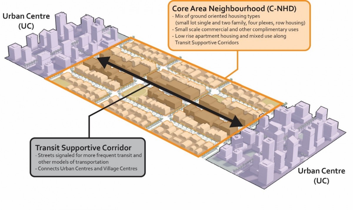 |
Figure 3.1: Transit Supportive Corridor Context. |
Permanent Growth Boundary
The Permanent Growth Boundary serves at the City’s Urban Containment Boundary. Lands within the Permanent Growth Boundary may be considered for urban uses within the 20 year planning horizon ending 2040. Lands outside the Permanent Growth Boundary will not be supported for urban uses. ALR and non-ALR land outside the Permanent Growth Boundary will not be supported for any further parcelization.
Temporary Use Permits
In accordance with the Local Government Act Section 492, an Official Community Plan may designate areas where Council may consider allowing temporary uses, and may specify general conditions regarding the issuance of temporary use permits in those areas. The temporary use designation is intended to apply to operations that are temporary in nature and the designation does not in itself permit specific uses on the designated sites. Within these areas, Council may, by resolution, issue a Temporary Use Permit and specify the conditions under which the temporary use be carried on. Upon the expiration of a Temporary Use Permit, the permitted uses revert to those outlined in the Zoning Bylaw.
Temporary Use Permits may be considered on all lands within the City of Kelowna. Temporary Use Permits should consider the fit within the character of the neighbourhood and surrounding uses to minimize conflicts and nuisances and as such should consider any mitigating strategies such as landscaping buffering, screening and operational details. Terms and conditions of the permit should specifically address an appropriate time duration up to the maximum limit under the Local Government Act (LGA).