2040 Transportation Master Plan
Forecasts and Trends


While predicting the future of cities has never been easy, there are good reasons to believe we are in a period of rapid change. Population growth, technology innovations, shifting demographics, and a changing climate will all continue to influence how people get around. While we are making the best use of available forecasting methods to guide our decisions, we will need to remain nimble and adapt to changing circumstances.
A complete summary is available in our TMP Existing and Future Conditions Technical Report.
The following global and national trends will impact transportation here in Kelowna. Many of these trends present both opportunities and challenges. If we are proactive, our responses to these trends could speed up progress toward our shared vision.
The heat waves, forest fires, and floods of recent years demonstrate that climate change is already affecting life in Kelowna. Scientists warn that greenhouse gas (GHG) emissions from the burning of fuels need to be cut in half over the next decade to avoid more catastrophic impacts.
As identified in Kelowna's Community Climate Action Plan, transportation accounts for just over half the GHG emissions in Kelowna. While electric vehicles will help, they are only part of the solution as it will take decades until most vehicles on the road are electric. Working to increase the share of trips made in Kelowna by walking, biking and transit will be critical.
As our climate changes, our infrastructure will have to be more resilient to withstand wetter, milder winters, and hotter, drier summers. For example, we have had to revise the design of bridges in Kelowna to allow for higher flood levels as our recent years have our understanding of extreme weather events.
Like many places in Canada, Kelowna’s population is growing older. Soon, one in four Kelowna residents will be over the age of 65. These residents will need improved transit and other mobility services to remain independent when they can no longer drive.
Retirees tend to travel less often and avoid peak hours compared to younger adults. As a result, we may see less pressure during the morning commute, but a filling in of the midday as the population grows.
Changing economic trends impact travel patterns. As people access more goods and services online or get them delivered, they are making fewer in-person shopping trips. However, this trend is increasing the number of delivery vehicles and other commercial traffic on our roadways throughout the day.
Rapidly growing cities, such as Kelowna, face the challenge of funding infrastructure for new development while also maintaining existing, aging infrastructure. About two-thirds of our current spending on roads is for maintenance, and this share is expected to rise as our infrastructure continues to age. At the same time, major transportation system upgrades are becoming warranted due to growth.
To help address the infrastructure deficit it will be important to increase our focus on maintaining existing infrastructure. It will also be important to balance the amount of infrastructure we build in different areas of the city with our financial capacity to maintain it over the long-term.
Increasing income inequality and the rising cost of living are becoming concerns for many residents. Transportation is often a household’s second biggest expense.
Neighbourhoods that offer more affordable transportation options, such as those in the Core Area, allow households to get by with one vehicle, or no vehicle, which can help offset increasing housing costs. For example, the savings from giving up one vehicle could increase the size of a mortgage that a household qualifies for by well over $100,000 or more.
For lower-income residents, not needing to own and maintain a car to get to work can mean the difference between affording groceries and having to use the food bank. More affordable transportation options, such as public transit or biking, can give residents access to employment and opportunities in the larger economy. To help address the rising cost of living it will be important to focus housing close to jobs and in areas with access to affordable travel options, such as the Core Area.
The current level of transformative travel innovation is more significant than it has been in over a century. Electric vehicles are here; they are growing in popularity and are a critical part of our efforts to reduce greenhouse gas emissions. In addition, emerging technologies and shared mobility services, such as carshare, ride-hailing, bikeshare, and shared e-scooters offer the on-demand flexibility of vehicle ownership at a lower cost.
It is possible that by 2040, many of the vehicles on our roads will be driverless. Some of these new driverless vehicles will likely belong to ride-hailing services, while others may belong to transport and delivery services. Benefits of these changes could include more convenient travel options, safer streets, and more independence for youth, the elderly, and people unable to drive. However, driverless vehicles could also lead to increased traffic congestion as more people travel and empty vehicles circulate.
More information is available in our discussion paper on Transportation, Technology, and our Changing Future.
The COVID-19 pandemic has greatly increased the number of people working from home. It is unclear how long this will last, though it is likely to continue in some form. Fewer people commuting each day could reduce the strain on the transportation network during peak hours. The pandemic has increased the number of people biking and walking and reduced transit ridership, although transit ridership has begun to rebound. So far, ridership is rebounding the most in the afternoon peak.
As one of the fastest growing cities in Canada, Kelowna is rapidly evolving. Its economy is diversifying and many of its neighbourhoods are transforming. Kelowna is becoming a more urban and dynamic city, and the pace of urban change is unlikely to let up.
Based on projections from BC Stats, and in coordination with the 2040 OCP, Kelowna’s population is expected to reach 180,000 by 2040. This makes us one of the fastest-growing regions in Canada, and is roughly in line with our growth rate over the past two decades. We anticipate continued steady growth and need to plan for it.
The 2040 OCP creates a strategy to accommodate this anticipated growth in alignment with the Imagine Kelowna community vision. The OCP focuses roughly three-quarters of future residential growth in Kelowna’s Core Area and five Urban Centres. These are areas where walking, biking, and transit are increasingly viable alternatives to driving. The remaining quarter of residential growth will occur in outlying Suburban Neighbourhoods that are mostly car dependent.
Job creation in Kelowna is expected to keep up with population growth, resulting in roughly one-third (25,000) more jobs in 2040. Many of these jobs will be in our Urban Centres or at major institutions like Kelowna General Hospital or UBC Okanagan. We also expect to see significant job creation in our industrial areas like the Gateway.
Kelowna is the Okanagan’s economic centre, and roughly one-quarter of jobs in Kelowna are filled by workers who commute from other places. Fifteen per cent come from the Westside and the South Okanagan, while 10 per cent come from Lake Country and the North Okanagan. This trend is expected to continue.
Relatively few trips involve people passing through Kelowna. About 90 per cent of the traffic crossing over the WR Bennett Bridge into Kelowna is heading toward a destination within the city, while only 10 per cent is just passing through. While Highway 97 is the transportation “spine” of the Okanagan, and critical for our region’s access to provincial and international markets, it is not a primary route for inter-provincial trade.
Kelowna will be home to another 45,000 residents by 2040. These residents will need to travel to get to work, school, shopping, and to visit friends and meet their other daily needs. Traffic congestion and emissions will get worse if all the city’s future residents drive as much as we do today.
To prepare the 2040 TMP, we started by modelling future transportation conditions across the city. The analysis looked at population growth in combination with the 2040 OCP Growth Strategy and the existing transportation network and travel behaviours to estimate what the future would look like in 2040 without a transportation plan to guide our investments.
Citywide outcomes provide one part of the picture, but it is important to recognize that future travel demand and traffic patterns will vary in different parts of the city. Some future trips will depend on driving, while others will be easier to accommodate with biking, walking and transit.
Projections of future travel patterns citywide and in different parts of the city are summarized below.
If we do nothing, by 2040 we estimate that the distance driven in Kelowna will grow by approximately 25 per cent. The 2040 OCP and TMP are designed to work together to mitigate this increase and keep it to 10 per cent (as described in the Targets section).
While population growth alone will require substantial future transportation investment to maintain Kelowna’s quality of life, the 2040 OCP and 2040 TMP will help mitigate future costs by focusing growth in the Core Area and investing in sustainable transportation modes. As travel distances shorten, more people living and working in the Core Area and Urban Centres will be able to walk, bike or take transit more easily, and when they do drive, they will not have to drive as far as residents living in the outer areas of the city. While the total amount of driving and congestion levels are still projected to increase citywide, it can be much less than it would have been if we continued to grow predominantly outwards.
Overall, traffic is expected to become busier and more complex within the Core Area, where residents commuting in and out of hillside neighbourhoods will compete for limited road space.
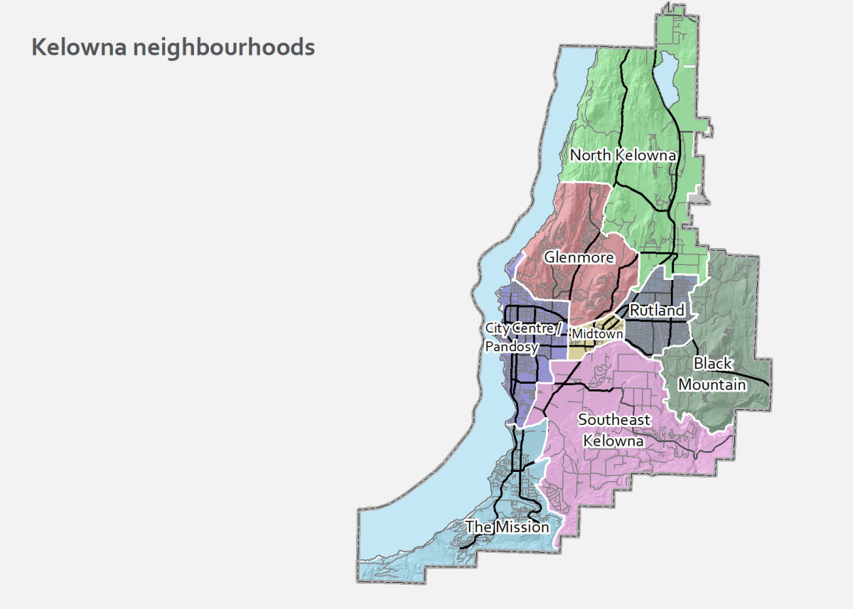
The triangular area between Downtown, Pandosy, and Capri-Landmark is a hub of activity for the Central Okanagan. Half of the city’s future growth is planned here. As a result, the number of trips in and out of this area is expected to grow 40 per cent by 2040. As well, the number of trips between destinations within this area could double.
It will not be possible or desirable to accommodate all this increased travel by driving. Existing road rights of way are limited, and adjacent land is in high demand. The challenge will be to shift as many short trips as possible to walking, biking and transit. Shifting short trips will free up road space for commercial vehicles and people who need to drive.
Midtown is the geographic centre of Kelowna, which means that many trips must pass through the area. It is a major destination that is home to one-third of the city’s retail space. The amount of travel to and from Midtown is expected to grow by 25 per cent by 2040.
Currently, the area’s long blocks funnel vehicle traffic onto only three east-west streets. Large distances between safe places to cross the street make walking feel less safe and inconvenient, while a lack of protected bike lanes makes biking uncomfortable. This means that nearly all travel within Midtown happens by driving, even for short distances.
Creating safer biking and walking facilities in this area would allow nearby residents to access Midtown destinations without having to drive.
This area already experiences some of the worst traffic congestion in the city. In the morning, most of the traffic consists of commuters leaving for work and school. In the afternoon, the traffic flow reverses as those commuters return home. The amount of travel in and out of the area is expected to increase 20 per cent by 2040.
The area’s low-density nature, distance from employment centres, and the layout of its streets mean it is challenging for walking, biking, and transit to compete with driving. While we can invest in some projects to increase vehicle capacity, they are limited, and the reality is that traffic in this area will continue to grow.
While adding more services nearby could avoid some trips out of the area, most residents will still need to travel for work at peak times. The best approach for managing peak-hour traffic congestion in this area will be to encourage residents to work from home, share rides, or drive during off-peak times.
By 2040, the amount of travel to and from Glenmore and the nearby hillside areas of Wilden and McKinley is expected to increase by 40 per cent. A lot more people live in Glenmore than work there, which results in a flow of commuters out of the area in the morning. Today, most of these people head south. However, as the number of jobs in the Gateway grows, we may see more of an even split between traffic heading north and south.
Glenmore’s main artery, Glenmore Road, connects Lake Country and central Kelowna. Traffic volumes on Glenmore Road are anticipated to grow by 25 per cent. It is likely that residents in McKinley and Wilden will continue to drive for most of their trips and use Clifton Road more often than Glenmore Drive when heading south.
Transit has moderate potential in the Glenmore area due to its layout and location “on the way” between UBC Okanagan and Downtown. The central location means residents make many medium distance trips, which makes them potentially within biking range. While the area’s hilly nature may be a barrier for some people, small electric vehicles (i.e., e-bikes, e-scooters) may provide an attractive alternative.
The amount of travel to and from Rutland, including the hillside neighbourhoods of Black Mountain, Kirschner Mountain, and Tower Ranch, is expected to increase 35 per cent by 2040.
As with other parts of the city with more residents than employment, Rutland will continue to see more traffic moving out of the area in the morning than in, and then reversing in the afternoon.
Trips within Rutland tend to be within biking range and relatively flat except for the bench. Trips between Rutland and other parts of the city tend to be longer, increasing the importance of transit.
As Lake Country continues to grow, the amount of travel into Kelowna from our northern neighbors is expected to increase 60 per cent by 2040. Currently, most Lake Country residents live in places where driving is the only convenient option. There is growth in industrial employment along the northern boundary, which will result in more trips from Kelowna residents to access these jobs.
As a result of growth at UBC Okanagan, the Kelowna International Airport and other businesses in the area, the amount of travel to and from the Gateway area is expected to increase 65 per cent by 2040. About two-thirds of this travel will come from Kelowna, and the other third is forecast to come from Lake Country and Vernon. A lot more people work in the Gateway area than live there. This means there is a surge of longer distance commuters flowing into the area in the morning, and then flowing out again in the afternoon.
Completing the Okanagan Rail Trail will make it much more comfortable to bike between Kelowna and Lake Country, though the distance is longer than what is typically considered biking range. Transit can be an option for these longer trips – particularly to the university – depending on how much of Lake Country’s growth happens in areas that can be easily serviced by transit.
As a long-term strategy, the Regional Transportation Plan recommends extending frequent and/or RapidBus transit service to Lake Country when sufficient densities make this economically feasible.
While the communities on the west side of Okanagan Lake will continue to grow, congestion at the bridge and entering Kelowna will limit vehicle growth in peak periods – but mid-day growth will continue.
Due to existing constraints and long trip distances, the focus of the City will be to work with the Province to create a fast and reliable transit spine along the Highway 97 corridor. This will increase the people-moving capacity of the bridge and highway, make more efficient use of the existing road network, and prevent buses from being stuck in traffic.
The Regional Transportation Plan recommends further study of accommodating an eastbound transit lane on the bridge during the morning rush hour to allow transit to bypass traffic and stay on schedule, as well as adding dedicated transit lanes along Harvey Avenue from the bridge towards UBC Okanagan.
It is anticipated that these and other projects on the provincial highway system will be looked at further as part of the next phase of the Ministry of Transportation and Infrastructure’s Central Okanagan Planning Study.
One of the most effective long-term congestion mitigation strategies is to reduce car-dependency by providing more convenient and realistic alternatives for getting around, especially during the morning and afternoon peaks. This requires a coordinated approach to land use and transportation that shortens trip distances and creates complete, connected, and safe bicycle, pedestrian, and transit networks between key destinations.
With traffic levels projected to increase, it is important to understand traffic congestion and options for managing it effectively. Increasing congestion levels are often a sign of a growing, vibrant, and economically productive city. Historically, traffic levels become heaviest when the economy is booming and notably decline during a recession.
Even if traffic congestion is a sign of a booming economy, people still don’t like being stuck in traffic. Often, the response to increasing traffic congestion is to increase roadway capacity by building new roads and widening existing ones. However, as discussed in The Congestion Paradox discussion paper, this approach can have negative impacts and is often expensive and ineffective over the long-term.
In Kelowna, the construction of new roads is constrained by steep hillsides, Okanagan Lake and protected agricultural lands. In the Core Area, there is little room to widen roads without buying land, tearing down homes or disrupting local businesses. This would be expensive and physically divide existing, established neighbourhoods, making Kelowna a less attractive and less healthy place to live. On average, the cost to widen a major road in the Core Area is estimated at $26 million per kilometre, but could be much higher in places where nearby properties are significantly impacted. This means that substantial tax increases or new sources of revenue would be needed to try and build our way out of congestion.
Even if the space and money were available, expanding roadways often reduces congestion to a smaller degree, and for less time, than initially expected. This is because when a new road opens -or an existing road is expanded- people typically respond by driving more until roadways fill back up. This rebound effect, called “induced demand”, can reduce the long-term congestion mitigation effects of roadway expansion projects.
While free-flow automobile travel during the morning or afternoon peaks may not be achievable in a rapidly growing, economically successful city like Kelowna, there are still several strategies that can be pursued to help manage congestion and reduce the rate at which it intensifies, including mode shift, developing a well-connected, complete street network, and taking a progressive approach to managing traffic congestion. These are described further below.
It is important to aim for congestion levels that are not too high and not unrealistically low to keep Kelowna moving while achieving the City’s vision and goals for transportation. This approach will help minimize the unintended negative consequences of building too much road capacity, while maximizing the effectiveness of our infrastructure investments. The recommended actions in the 2040 TMP were identified keeping this balance in mind.
Developing a well-connected, complete street network will help keep Kelowna moving. Within the busy Core Area, streets with high traffic volumes, long blocks and limited crossings will make it challenging to accommodate growing numbers of people walking, biking, and taking transit. Streets with high vehicle speeds will require greater space and separation for people to walk and bike safely.
To maximize the people-moving capacity within the Core Area, we must re-think our existing streets and develop a well-connected grid network that thoughtfully accommodates all modes of travel. While some streets will need additional right-of-way to better accommodate people walking, biking, and taking transit, it is less than if we were trying to accommodate all future trips by driving.
To keep Kelowna moving, it will be necessary to shift as many future trips as possible to more sustainable transportation modes that can move more people in the same amount of space, such as walking, biking, transit, and emerging modes. This will increase the number of people that can move through our transportation network while giving Kelowna residents more choices to get around. This will help reduce the growth of traffic congestion and prioritize road space for moving goods and other trips that must be made by driving.
The best opportunities for mode shift are within the Urban Centres and Core Area, where the terrain is relatively flat, and some supporting infrastructure for walking, biking and transit is already available. Increased densification will result in shorter trip distances, thus removing the primary barrier to walking and biking for nearby residents. If the City takes consistent and complementary action to ensure the transportation network provides safe, attractive, and convenient infrastructure for walking, biking and transit in these densifying areas, the number of trips shifted to these modes can be maximized.
Performance measures and targets related to congestion, such as travel times, mode share, and distance driven are in Chapter 6 Implementation.
To keep Kelowna moving we need to make it easier for people to drive less. For most people in Kelowna, driving is the default way to get around. This makes sense, given how much of the city was built around driving and the convenience of personal vehicles. A car or truck leaves when we want, provides door-to-door service, and can carry lots of cargo. Making it easier for people to drive less will involve offering a range of new options for different types of trips.
By encouraging these options in the neighbourhoods where they make sense, we can make car-free or car-light living viable for more households.
Walking is the simplest and most affordable way to travel. It improves our health and well-being, reduces congestion, and cuts emissions. It is much cheaper to build and maintain sidewalks and pathways than it is to build roads.
Trips need to be short for walking to be an option. About a quarter of trips in Kelowna are less than 1.5 kilometres, which is a twenty-minute walk. However, when walking, even minor detours can become major barriers. Connected street grids with short blocks and many safe places to cross busy roads allow people to reach more destinations within a reasonable time.
Biking is a low-cost way to travel moderate distances that improves our health and well-being, reduces congestion, and cuts emissions.
Travel times by bike are often competitive with driving for trips under three kilometres, which is roughly a 10-minute bike ride. A little over half of the trips made by residents in Kelowna’s Core Area (essentially the parts of the city that are flat and urbanized) fall into this category.
Adequate parking for bikes at peoples' origin and destination is essential for making biking feasible. Bike parking is less expensive to provide than vehicle parking and takes up much less space.
Like with walking, a lack of routes protected from vehicle traffic can be a barrier. Hills can make biking more challenging and less attractive. However, the increasing popularity of e-bikes could reduce the impact of this issue.
Moving forward, e-bikes, e-scooters and other small electrically powered vehicles are going to become more common. These vehicles make it easier for more people to ride longer distances, get up and down hills, and carry cargo.
For Kelowna to keep growing without worsening gridlock, we need to find ways to move more people along our already existing roads. Transit moves large numbers of people but does not offer door-to-door service. For transit to be convenient, transit needs to be direct, frequent and the start and end points need to be within walking distance to a bus stop.
Higher capacity transit systems such as streetcar or light rail are a long way off in Kelowna. Still, we can work incrementally toward them by adding new homes and jobs along corridors that may one day support higher capacity transit.
The main challenge for transit will be making travel times competitive with driving. Adding more frequent service to a route means less time waiting for the bus. Streamlining stops and giving transit vehicles priority on our roads means buses move faster, saving people time and reducing operating costs. Over time, as the value of land in the Core Area increases, parking supply will naturally decrease. This will increase the cost of parking and make transit more attractive.
While more future trips will be made on foot, by bike, or on transit, many will still be more practical by driving. Inclement weather, transporting passengers or cargo, physical ability and other factors mean people will continue to need a car or truck sometimes.
To help reduce car dependency and facilitate car-light living, biking, walking and transit all need to be viable alternatives to driving a personal vehicle. In addition, emerging technologies and new transportation modes can help fill in some of the gaps. For example, carshare services can offer short-term car rentals and trucks or vans for moving large items.
Ride-hailing can be used for late night or early morning trips that are difficult to serve by transit. Shared e-scooters and e-bikes can help people get to or from a bus stop when the trip is too far to walk. People may also use these small electric vehicles for their entire trip or to help cover longer distances and hilly terrain.
For most people, living in Kelowna without a car or with fewer cars will require more than one of the options above. Residents in neighbourhoods that have good access to multiple transportation options will be able to choose the travel mode that works best for each trip. This will give them the best chance of going car-free or car-light as Kelowna grows. Providing more housing options in less car dependent neighbourhoods is an integral part of Kelowna's long-term vision.