2040 Official Community Plan
The Core Area


The Core Area contains the greatest diversity of land uses and plays the widest range of roles in our community, from vibrant residential neighbourhoods, transit corridors and their Village Centre hubs to large format retail to service commercial uses and industrial lands. In part because of this diversity, the Core Area is one of the districts most critical to the City’s long-term growth management plan.
The building block of the Core Area is the neighbourhood. Situated just outside of our Urban Centres, these neighbourhoods will be diverse, with a range of ground-oriented housing options that meet the needs of all Kelowna residents. Transit Supportive Corridors are the connective tissue that link these neighbourhoods to Village Centres both by providing easy transportation connections and options, and by supporting fronting land uses that feature denser residential development and mixed-use land uses. Within the Core Area, Village Centres are the secondary hubs of local activity, providing a range of daily needs like shopping and services for nearby residents.
The Core Area also acknowledges the immense regional value provided by the commercial and service commercial businesses located around the Highway 97 corridor. In fact, the unique and vital role that this area plays is encouraged and reinforced, ensuring that Kelowna remains a hub for the Okanagan Valley and the Southern Interior region.
The approach to land use in the Core Area focuses on modest residential growth primarily through residential infill in existing neighbourhoods, with some targeted redevelopment in the Core Area’s Village Centres and along Transit Supportive Corridors. Great public spaces and increased greenery in these neighbourhoods are critical to quality of life they offer and supported in these policies and those found in Chapter 10: Parks.
Larger shopping destinations like big box stores or shopping centres continue to be focused near or along Highway 97. Industrial uses continue to grow and diversify in Kelowna’s North End area, and in strategic locations along Enterprise Way.
The City and the community share responsibility in shaping the Core Area over the next 20 years. New development should carefully consider it’s neighbourhood context, keeping in mind the scale of existing residential neighbourhoods, but supporting a shift to a new feel in Village Centres and along Transit Supportive Corridors. The City should support this evolution with strategies to create more walkable environments and focusing more investment in transportation options, parks and other amenities.
Policy 5.1.1. Village Centre Composition.
Encourage the development of a range of services, small scale and specialty retail, and limited office employment in scale with supporting low rise residential development in Village Centres to serve the surrounding Core Area Neighbourhoods. Support these uses with additional parks, plazas and other public realm improvements.
Policy 5.1.2. Village Centre Density.
Target an overall density of 30 to 60 jobs and people per hectare in Village Centres in the Core Area.
Policy 5.1.3. Village Centre Retail Corridors.
Locate retail and restaurant uses in Village Centres at grade, prioritized along Transit Supportive Corridors, to create a more vibrant pedestrian and transit supportive environment.
Policy 5.1.4. Cook Truswell Village Centre.
Continue to support the evolution of the Cook Truswell Village Centre into a mixed use tourist commercial destination by supporting development that contributes to the following vision for the area:
- A mix of tourist accommodation, with supporting residential and commercial development;
- Buildings that are generally up to six storeys in height, with opportunities for taller buildings being explored with additional considerations such as:
- Building design that maximizes views of the lake;
- Uses at grade, such as retail commercial or restaurants to contribute to a lively pedestrian-oriented tourist environment;
- Significant publicly accessible parks, plazas and other public realm improvements;
- Enhancement of the public’s access and enjoyment of the waterfront at Okanagan Lake; and
- Protection, restoration and dedication of Okanagan Lake foreshore and other riparian areas.
- Orientation of buildings towards Truswell Road, creating a small retail street;
- Increased transportation connectivity from Lakeshore Road to Okanagan Lake and surrounding neighbourhoods to the east.
Policy 5.1.5. Lakeshore Village Centre.
Support the continued development of the Lakeshore Village Centre that shares the following characteristics:
- A mix of residential and commercial uses that serve the Lower Mission neighbourhoods, with commercial uses located along the Lakeshore Road Transit Supportive Corridor; and
- Buildings up to approximately six storeys in height.
Policy 5.1.6. Glenmore Village Centre.
Support development in the Glenmore Village Centre to serve citizens in neighbourhoods in north Kelowna, such as Glenmore, Wilden, and McKinley. Development in the Glenmore Village Centre should share the following characteristics:
- Commercial uses located east of Glenmore Road;
- Buildings up to six storeys in height; and
- Orientation of buildings along Brandt’s Creek towards the creek and trail system.
Policy 5.1.7. Guisachan Village Centre.
Support mixed use commercial and residential development up to six storeys in height in the Guisachan Village Centre, with commercial uses being oriented towards the Gordon Transit Supportive Corridor.
Policy 5.2.1. Transit Supportive Corridor Housing and Services Mix.
Encourage housing options such as stacked rowhousing and low rise apartments alongside local services to provide the residents and jobs that support transit and active transportation. Discourage underdevelopment of properties, such as single detached, duplex and houseplex housing along Transit Supportive Corridors.
Policy 5.2.2. Transit Supportive Corridor Building Heights.
Encourage buildings up to six storeys in height in Core Area Neighbourhoods that abut Transit Supportive Corridors. Consider buildings above six storeys as identified through an area planning processes or where the project is adjacent to higher capacity transit along Highway 97, or at a major intersection, with due consideration for the context of the surrounding neighbourhood.
Policy 5.2.3. <Deleted>
Policy 5.2.4. Commercial Uses in Transit Supportive Corridors.
Support commercial uses mixed with residential uses along Transit Supportive Corridors. Require commercial uses at grade where there are existing commercial services and in strategic locations as identified through area planning processes. Consider commercial only buildings that serve the surrounding neighbourhood along Transit Supportive Corridors based on surrounding neighbourhood context, including population, amenities, proximity to Active Transportation Corridors and other characteristics. Discourage large scale office buildings and direct those uses to Urban Centres and Mixed Employment Areas.
Policy 5.2.5. Corridor Access and Consolidation.
Encourage consolidation of small properties and location of automobile accesses from lanes or side streets to reduce or eliminate the number of accesses directly onto Transit Supportive Corridors.
Policy 5.2.6. Burtch / Harvey Area Redevelopment Plan.
Consider greater heights and densities than afforded in the Core Area Neighbourhood designation in the Burtch / Harvey area as outlined on Map 16.1, only at such time as an Area Redevelopment Plan initiated by the property owners is completed.
Policy 5.3.1. Core Area Neighbourhood Infill.
Encourage ground-oriented residential uses such as house-plexes, townhouses and narrow lot housing up to approximately 3 storeys to fit with the existing neighbourhood development pattern. Consider more intensive ground-oriented housing on existing lots which are significantly larger than the surrounding lot pattern. Consider larger infill projects, including those where lot consolidation is required, where they are in a Transit Supportive Corridor transition area, on a block end or near community amenities including, but not limited to, parks and schools, as outlined in Figure 5.3.
Policy 5.3.2. Transition from Transit Supportive Corridors.
Provide a transition area allowing for housing up to 4 storeys in height, as outlined in Figure 5.3, between the larger buildings along Transit Supportive Corridors and existing neighbourhoods in the Core Area. Encourage design approaches that respect adjacent lower density residential areas. Consider commercial uses in the transition area where consistent with Policy 5.3.8 Local Commercial Integration.
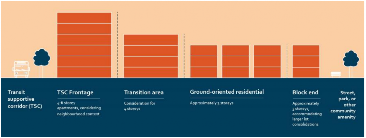 |
| Figure 5.3: Core Area Neighbourhood Cross Section. |
Policy 5.3.3. Strategic Density.
Where a proposed development in Core Area Neighbourhoods is not adjacent to a Transit Supportive Corridor, consider support for proposals for stacked townhouses, low rise apartments and mixed-use buildings based on the degree of alignment with the following factors:
- The property, at the time a rezoning or development permit application is made, is significantly larger than the typical lot size or lot pattern in the adjacent area; and
- The project proposal illustrates that the larger buildings will be able to sensitively transition their height and massing towards adjacent lower density Core Area Neighbourhoods, with the first priority being a transition to ground-oriented multi-unit housing within the project; and
- The project proposal includes a public park component; and
- The project proposal includes an affordable housing and/or rental housing component; and
- The project is located close to services such as public transit routes, active transportation routes, bike routes, and commercial uses; and
- Projects of similar size and scale are already located in the area; and
- The project is consistent with applicable Development Permit Guidelines including by not limited to Form & Character, Natural Environment, Hillside, Farm Protection, and Hazardous Conditions Guidelines.
Policy 5.3.4. Casorso Road Area Redevelopment Plan.
Consider redevelopment of the Casorso Road properties, as outlined on Map 16.1, only at such time as an Area Redevelopment Plan is completed, in keeping with Policy 5.3.3. This plan should be initiated by the property owners, and include at minimum, a community park of approximately 2.0 hectares in size fronting Casorso Road and linear park and pedestrian connections from Wintergreen Drive and Invermere Road to Casorso Elementary School.
Policy 5.3.5. Existing Uses and Scales.
Support stacked townhouses, low rise apartments and mixed use buildings in Core Area Neighbourhoods where the property was zoned to allow for such uses on the date that the Official Community Plan was adopted.
Policy 5.3.6. Small Lot Development.
Deleted as aspects of this policy are covered in Policy 5.3.1 - Core Area Neighbourhood Infill.
Policy 5.3.7. Heritage District Housing.
Allow for gentle densification in the form of ground-oriented residential uses such as single detached homes, duplexes house-plexes using the guidance outlined in Chapter 23: Heritage Conservation Areas. Encourage and incentivize adaptive re-use of existing homes where heritage assets are identified to balance historical conservation with additional housing opportunities.
Policy 5.3.8. Local Commercial Integration.
Support the sensitive integration of small scale local commercial uses, such as convenience stores and cafés, into Core Area Neighbourhoods to promote those services in easy walking distance of residents. Such uses should be located at high profile intersections of collector and arterial streets. Discourage such uses mid-block.
Policy 5.3.9. North End Plan.
Use the North End Plan to guide the redevelopment of properties in the North End neighbourhood within the Core Area. Key guidance includes:
- Support for buildings up to 6 storeys along north side of Recreation Ave;
- Support apartments up to 6 storeys between Manhattan Dr and Guy St to allow for increased density adjacent to the Mill Site and along the North Side of Recreation Ave; and
- Support for neighbourhood commercial uses in the Walrod Park Neighbourhood.
Policy 5.4.1. Accessible Community Services.
Prioritize services required to meet daily needs in the Village Centres first to create a more equitable and inclusive community while continuing to support such services throughout the Core Area. These services include, but not limited to:
- Medical, health and wellness services;
- Child care facilities, schools and smaller library branches;
- Places of worship and other community gathering spaces;
- Food retail, services and programs; and
- Banks and credit unions.
Policy 5.4.2. Safety Net Supports and Services.
Allow safety net supports and services in the Core Area for people experiencing homelessness. Safety net supports and services include, but are not limited to, shelters and the supports associated with the shelter. Recognize that shelters are used by a diversity of people with different needs such as women fleeing violence, youth and adults. Ensure information is provided to the community to foster positive relationships and promote acceptance for these supports, services and the citizens that are using them.
Policy 5.4.3. Accessible and Welcoming Core Area.
Design civic facilities, public spaces, streetscapes, infrastructure, programs and services in the Core Area that are accessible, available and inclusive of all ages, incomes and abilities, including seniors, people with diverse abilities, Indigenous people, and newcomers.
Policy 5.4.4. Public Space through Future Development.
Develop policies and regulations that incentivize the provision of onsite publicly accessible open space early in planning process to further enhance the public amenities in the Core Area to enhance overall development benefit.
Policy 5.4.5. Core Area School Sites.
Encourage the retention of existing schools and the location of new schools in central areas in Core Area Neighbourhoods and Village Centres that are easily accessible by children. Locations within the Core Area should incorporate design approaches that prioritize the needs of children while responding to smaller land acquisition requirements, including, but not limited to the following approaches:
- Shared use of facilities, sports fields and playgrounds;
- Pedestrian oriented access and site circulation;
- Pick-up and drop off locations that minimize impacts on the road network, but continue to prioritize the safety of students, faculty and parents;
- Increased building heights; and
- Reduced parking standards.
Policy 5.4.6. Post-Secondary Institutions.
Consider opportunities for post-secondary institutions and satellite campuses in Core Area locations well served by the frequent transit network and near an Urban Centre.
Policy 5.4.7. Child Care Spaces.
Facilitate the development of childcare spaces throughout the Core Area including accessible, affordable, and inclusive spaces that meet the needs of the community.
Policy 5.4.8. Walled Developments.
Discourage developments enclosed on all sides by walls, gates or other physical or visual barriers that hinder efforts to create more pedestrian, bicycle and transit friendly communities, block access to public park land or inhibit the efficient use of infrastructure.
Policy 5.5.1. Core Area Natural Spaces.
Encourage nature within the Core Area with design elements that include, but are not limited to:
- Urban forestry;
- Habitat for native and pollinator species; and
- Natural connections such as wildlife corridors and creeks.
Policy 5.5.2. Urban Forest Canopy.
Recognize the critical role tree canopy cover plays in pedestrian comfort, cooling of the urban heat island, habitat for local animal species and beautification of the public realm. Encourage the integration of trees in Core Area streetscape improvement projects and on private property with adequate growing medium, while protecting existing mature trees where possible.
Policy 5.6.1. Large Format Commercial.
Support large format retail and other commercial development that is car dependent to Regional Commercial lands to provide easy access to regional vehicle traffic. Do not support such uses in Village Centres or Core Area Neighbourhoods.
Policy 5.6.2. Transit Oriented Regional Commercial Lands.
Support buildings up to 12 storeys in Transit Oriented Areas on Regional Commercial lands. Development on Regional Commercial lands adjacent to Transit Supportive Corridors should locate buildings closer to and oriented towards the street, provide additional landscaping treatments, and locate surface parking in the rear of buildings.
Policy 5.6.3. Highway 97 Streetscape.
Collaborate with the Ministry of Transportation and Infrastructure to advance beautification efforts along Highway 97, with due consideration for the timing of other infrastructure improvements along the corridor. In addition, prioritize landscaping, street trees and separated pedestrian facilities in new development along the Highway 97 corridor, recognizing its role as a higher capacity transit and screening surface parking lots from view.
Policy 5.6.4. Pedestrian Priority in Parking Lots.
Create a safe and pleasant pedestrian experience in Regional Commercial lands with dedicated pathways that clearly delineate pedestrian space. Landscaping should be designed to maximize shade in the summer months.
Policy 5.6.5. Protection of Commercial Space.
Support the intensification of existing car-oriented sites on lands designated Regional Commercial by increasing the scale of existing buildings or by adding new commercial space on underutilized land, such as surface parking lots. Discourage development that reduces the amount of commercial space available in Regional Commercial lands.
Policy 5.6.6. Residential Development on Regional Commercial Lands.
To continue focusing residential growth in strategic locations such as Urban Centres, Village Centres and Core Area Neighbourhoods, discourage residential development on Regional Commercial lands. Consideration for residential development may be explored where a project proposal meets some or a combination of the following:
- The project is within a Transit Oriented Area;
- The project is located within 200 metres of a higher capacity transit station;
- The project is located within 200 metres of existing park spaces and/or other amenities;
- The project proposal includes an affordable and/or rental housing component;
- The project proposal includes a significant public space or amenity component; and
- The residential uses are secondary to the commercial uses with no net loss of commercial floor area.
Policy 5.6.7. Office Development on Regional Commercial Lands.
To ensure that employment density and transportation objectives in Urban Centres and Village Centres are met, discourage the development of large office projects on Regional Commercial lands. Such projects may be considered where they are within 200 metres of a higher capacity transit station.
Policy 5.6.8. Regional Commercial Mixed Use Node.
Notwithstanding Policies 5.6.6 and 5.6.7., consider development proposals for mid-rise mixed use development on properties on the east side of Highway 97 where it intersects with Highway 33. Proposals should transition height and density downward towards adjacent Core Area Neighbourhoods and include amenities that serve those neighbourhoods.
Policy 5.6.9. Service Commercial Lands Protection.
Encourage the retention of service commercial uses in Regional Commercial lands where such uses do not front Highway 97, recognizing the unique role that they play in the City’s economy. Discourage the encroachment of office space, and residential uses into these lands.
Policy 5.7.1. Kelowna General Hospital.
Work with Interior Health to support the continued growth of Kelowna General Hospital, respecting the context of the surrounding neighbourhoods, through the implementation of the Hospital Area Plan.
Policy 5.7.2. Health District Transit Oriented Area.
Support low-rise buildings up to 6 storeys, with due consideration of helicopter operations at Kelowna General Hospital and in keeping with the district’s identification as a Transit Oriented Area. Encourage lot consolidation where apartment housing is proposed.
Policy 5.7.3. Health District Neighbourhood Services.
Strategically focus health services and other services that support local residents and employees in the following ways:
- Support a mix of health and commercial services, integrated with housing opportunities;
- Provide health and/or commercial services at grade along Pandosy Street south of Royal Avenue and along Rose Avenue; and
- Limit health and commercial services near the Heritage District.
Policy 5.7.4. Cottonwoods Care Centre.
Support the continuation of health services uses at the Cottonwoods Care Centre, recognizing it as a critical health care facility for the City.
Policy 5.8.1. Protection of Industrial Lands.
Discourage the re-designation of industrial lands and ensure their use for industrial purposes to protect employment, production, manufacturing, warehousing, logistics and repair functions in the city. This includes limiting residential and commercial uses within industrial areas that promote speculation and make developing industrial uses challenging.
Policy 5.8.2. Employment-Intensive Industrial.
Increase the employment density of industrial land in the Core Area by supporting industrial uses that make more efficient use of underutilized land. Discourage new commercial storage facilities in the Core Area.
Policy 5.8.3. North End Industrial Lands and Mixed Employment.
Support the growth of industrial development and mixed employment as guided by policy in the North End Neighbourhood Plan, including but not limited to new regulatory and zoning approaches.
Policy 5.8.4. Regional Collaboration for Industrial Lands.
Support a regional approach to managing industrial lands, recognizing that industrial business needs are connected across the region, with different local contexts playing unique and important roles.
Policy 5.9.1. Equitable Food Access.
Encourage the inclusion of small and mid-size grocery stores, seasonal farmers markets and emergency food services in Village Centres and Core Area Neighbourhoods.
Policy 5.9.2. Farmer’s Markets.
Support the development of both year-round and seasonal farmer’s markets in the Core Area to provide access to healthy food options.
Policy 5.9.3. Urban Agriculture.
Encourage urban agriculture, that uses integrated pest management practices, as a way of supplementing the local food system and reducing greenhouse gas emissions associated with food production, processing, and transportation. In the Core Area, support and encourage urban agriculture using approaches that include, but are not limited to:
- Food production on public and private land including rooftops, beehives, and edible landscaping on residential boulevards, park land, backyards, and rights-of-way;
- Multi-residential shared gardens and services (i.e. water and storage) in new developments; and
- Private and non-profit sector universally-accessible community gardens, considering the use of City-owned land for use of community gardens where appropriate.
Policy 5.9.4. Indigenous Forest Gardens.
Partner with syilx/Okanagan communities to develop, forest gardens that focus on the cultivation of native and culturally important species of plants for food and medicine.
Policy 5.10.1. Agricultural Land Protection.
Retain the agricultural land base for the long-term by supporting the Agricultural Land Reserve (ALR) and by protecting agricultural lands from the impacts of adjacent development and redevelopment.
Policy 5.10.2. Urban-Rural Interface Uses.
Where a property is adjacent to agricultural lands, encourage land uses that are compatible with adjacent agricultural uses, such as urban agriculture and passive recreational uses. Encourage uses that accommodate vulnerable populations, such as seniors, children and people with health challenges to parcels that are not adjacent to agriculture to limit interface incompatibilities.
Policy 5.10.3. Urban-Rural Buffers.
Where a property is adjacent to land in the Agricultural Land Reserve (ALR) ensure that development limits associated negative impacts on adjacent agricultural operations by including appropriate buffers, setbacks and site planning, consistent with the Farm Protection Development Permit Guidelines outlined in Chapter 22: Farm Protection Development Permit Areas.
As the City focuses growth in the Core Area, urban neighbourhoods will become increasingly desirable as more people choose to live close to services and amenities. By expanding the variety of housing forms and tenures, the Core Area will be better able to provide housing options for all citizens, including smaller households and families. Also, by encouraging the creation of new rental housing and protecting existing rental housing, there will be more affordable and attainable housing options for low-income households. As land values increase in the Core Area, it will be important to promote strategies and actions that limit displacement of low-income citizens currently living in these neighbourhoods.
Partnerships between different levels of government, development community and non-profit housing organizations will be needed to provide stable, affordable housing in the Core Area. The City will prioritize investment in land for affordable housing within the Core Area to ensure that affordable housing is in proximity to sustainable transportation options, services and amenities.
Policy 5.11.1. Diverse Housing Forms.
Ensure a diverse mix of low and medium density housing forms in the Core Area to support a variety of household types and sizes, income levels, life stages and abilities, including affordable, rental, and supportive housing.
Policy 5.11.2. Diverse Housing Tenures.
Encourage a range of rental and ownership tenures that support a variety of households, income levels and life stages. Promote underrepresented forms of tenure, including but not limited to co-housing, fee-simple row housing, co-ops, and rent-to-own.
Policy 5.11.3. Ground Oriented Housing.
Incorporate ground-oriented units in the design of multi-family developments in the Core Area to support a variety of household types and sizes.
Policy 5.11.4. Accessible Site Design.
Integrate universal design features and principles to create housing options for people of all ages and abilities including those aging in place.
Policy 5.11.5. City Land Acquisition.
Prioritize land acquisition and housing partnerships in the Core Area, in addition to Urban Centres, to support affordable rental housing that is in close proximity to services and amenities.
Policy 5.11.6. Social Connections through Design.
Encourage housing design that incorporates front porches, gardens, greenspace and children’s play areas to foster social connections, inclusion and intergenerational relationships.
Policy 5.11.7. Residential Amenity Space.
Encourage new multi-family developments to have both common and private amenity space.
Policy 5.11.8. Bedroom Composition.
Encourage new units to include a variety of bedroom unit types as guided by the City of Kelowna's Housing Needs Assessment.
Policy 5.12.1. Subsidized Housing & Housing with Supports.
Prioritize the development of subsidized housing and housing with supports in the Core Area in addition to the Urban Centres, particularly near employment, public transit, services and amenities. Promote acceptance to the community for these supports, services and the citizens that are using them.
Policy 5.12.2. Displacement Impacts.
Ensure Core Area planning initiatives and significant redevelopment opportunities include affordable housing and access to services to ensure low to moderate income renters are protected from displacement effects.
Policy 5.12.3. Tenant Assistance.
Ensure that tenants displaced by redevelopment receive fair relocation assistance from the developer. Such relocation assistance is intended to help assist tenants retain their access to services and amenities, such as employment, transportation and schools.
Policy 5.12.4. Protection of Mobile Home Parks.
Prioritize retention of mobile home parks as an important source of affordable housing in our community. Only consider redevelopment of mobile home parks if 1:1 replacement of affordable units is included in the redevelopment.
Policy 5.12.5. Redevelopment of Mobile Home Parks.
During redevelopment, ensure owners of mobile home parks create and implement a viable relocation plan for current tenants and provide them with a first refusal to purchase, as per Council Policy #229.
Policy 5.13.1. Protection of Existing Rental Stock.
Ensure retention or replacement of existing rental units as redevelopment occurs in the Core Area through planning tools that include, but are not limited to, Rental Only Zoning.
Policy 5.13.2. Rental Conversion.
Prohibit the conversion of existing residential rental buildings with greater than six units to condominium status when rental vacancy falls below five per cent in Kelowna, unless the conversion is for the purpose of creating affordable rental housing with a Section 219 covenant registered on each strata title.
Policy 5.13.3. Short-Term Rentals.
Ensure short-term rental accommodations do not negatively impact the long-term rental housing supply.

To support the transformation of the Core Area areas to a more resilient low carbon future, the 2040 OCP envisions expanded roles for transit, walking and biking.
The availability of frequent transit service, protected bike lanes and more walkable streets will facilitate a high level of connectivity between the Core Area neighbourhoods and the services and employment located in the nearby Urban and Village Centres. In particular, the extension of the frequent transit network to align with Transit Supportive Corridors will improve connections to destinations across the City over time.
To realize this vision, the City and developers will need to partner on frontage improvements on key corridors to support frequent transit investments and enhance walkability. The City will continue to make strategic investments in protected bike lanes, local street urbanization works and pursue partnerships with BC Transit to establish the frequent transit network.
Policy 5.14.1. Walkability.
Promote safety and comfort of pedestrians through the design of streets and sidewalks that integrate street tree planting, enhanced public realm treatments, street furniture, curb-side parking and parkettes.
Policy 5.14.2. Roadway Congestion.
Recognize and accept that Kelowna’s streets and parking will become busier as the city grows. Reduce reliance on automobiles as redevelopment occurs in the Core Area by shifting trips away from driving by creating walkable streets, protected bike routes and investing in improved transit service.
Policy 5.14.3. Pedestrian and Biking Connectivity.
With new developments, require dedication of on-site walking and biking paths as outlined in Map 13.3 to provide links to adjacent parks, schools, transit stops, recreation facilities, employment areas and other activity areas.
Policy 5.14.4. Base Level Transit Service.
Prioritize basic transit service for all citizens in the Core Area in Transit Service Plan updates to ensure diverse transportation options in areas with population densities that meet acceptable performance standards to ensure financial viability of service.
Policy 5.14.5. Frequent Transit.
Establish a network of frequent transit routes along key corridors to link Core Area Neighbourhoods and Village Centres with Urban Centres as well as key institutional and community services such as Kelowna General Hospital, UBCO, Okanagan College and major recreation areas.
Policy 5.14.6. Active Transportation Corridors.
Establish Active Transportation Corridors that are designed for bicyclists and pedestrians of all ages in accordance with the objectives of the Pedestrian and Bicycle Master Plan.
Policy 5.14.7. Bicycle-oriented Development.
Prioritize bicycle parking and end-of-trip facilities through site planning and design of new development to ensure biking is an attractive and convenient transportation option.
Policy 5.14.8. Urban Street Network.
Enhance street network connectivity and redundancy; strengthen people capacity to improve sustainable transportation and make it easier to access the surrounding major road network.
Policy 5.14.9. Access Management.
Protect the functionality of Active Transportation Corridors, transit supportive corridors and arterial roads by limiting direct driveway accesses. Ensure that new development takes vehicular access via laneways or secondary streets. Where that is not possible, encourage lot assemblies that reduce the total number of driveway accesses.
Policy 5.15.1. Complete Streets.
Design streets to accommodate various combinations of transportation modes and uses, recognizing the intended role of a street in supporting key transportation networks (e.g. Active Transportation Corridor, Frequent Transit, Highway). Designs should prioritize efficient movement of people over vehicles to optimize future road capacity.
Policy 5.15.2. Transit Supportive Corridor Streets.
Create pedestrian-friendly tree- lined streetscapes along Transit Supportive Corridors , providing easy and comfortable movement along the corridor.
Policy 5.15.3. Highway 97.
Recognize the role that Highway 97 plays as both a higher capacity transit corridor and goods and services transportation link between Kelowna and its business markets.
Policy 5.15.4. Highway Permeability.
Work with Ministry of Transportation and Infrastructure to improve access across provincial highways for all modes to promote neighbourhood connectivity within the Core Area.
Policy 5.15.5. Transit Priority.
Utilize transit priority measures to optimize transit travel time on Frequent Transit Routes.
Policy 5.15.6. Transit Infrastructure.
Ensure frequent transit network routes are supported by key infrastructure (i.e. transit stops, bus pull out bays, bus shelters, benches, sidewalks, lighting, accessibility features, or other transit amenities) to optimize transit service in the Core Area.
Policy 5.15.7. Safe Crossings.
Create safe and accessible crossing opportunities on collectors and arterials.
Policy 5.16.1. Streets as Public Space.
Supplement park space in the Core Area by providing other places for people to gather, including but not limited to shared spaces, urban plazas and activation at street intersections and mid-block connections. To further support activity in these spaces, discourage the use of window bars and roll down panels on building facades in Village Centres and along Transit Supportive Corridors.
Policy 5.16.2. Local Streets.
Create a pedestrian friendly environment on local streets with a continuous boulevard treatment to support a robust urban tree canopy.
Policy 5.16.3. Neighbourhood Short-Cutting.
Assess options to mitigate cut-through vehicle traffic through traffic calming, traffic diversion and other design when considering development applications and infrastructure investments.
Policy 5.17.1. Okanagan Rail Trail Protection.
Ensure the long-term protection of the Okanagan Rail Trail by avoiding encumbrances within the Okanagan Rail Trail corridor, including but not limited to: driveways, crossings, and utilities.
Policy 5.18.1. Parking Management.
Use parking management strategies to ensure adequate turnover and availability in high demand areas and to encourage greater uptake of sustainable transportation options.
Policy 5.18.2. Parking Spillover.
Introduce parking management strategies to reduce the impact of new multi-family residential parking on Core Area neighbourhood streets.
Policy 5.18.3. Shared Mobility Access.
Adapt management of curb space to improve access to shared mobility options and reflect changing community priorities (e.g. car share, electric vehicle charging stations, ride-hailing and emerging mobility options).
Policy 5.18.4. Road Capacity Increases.
Prioritize the removal of on street parking over land acquisition when exploring road capacity increases, with due consideration of the road’s character and function.
Policy 5.19.1. Parking Relaxations.
Do not require residential vehicle parking within Transit Oriented Areas in the Core Area, except parking for people with disabilities. Consider vehicle parking requirement relaxations in other areas or projects, where:
- Mode share shifts are anticipated or have been realized;
- A viable car-sharing program is provided; or
- Additional bicycle parking and end-of-trip facilities that exceed bylaw requirements.
Policy 5.19.2. Parking in Core Area Parks.
Limit the area used for automobile parking in Core Area parks, reflecting the constrained land area and greater mobility options in these centrally located neighbourhoods.
Policy 5.19.3. Leverage Cash-in-Lieu.
Explore opportunities to expand cash-in-lieu parking program to Core Area neighbourhoods to fund sustainable transportation priorities and support climate action.
Policy 5.19.4. Electric Vehicle Charging.
Integrate electric vehicle charging stations in off-street parking plans for new multi-family, institutional and commercial developments.
Policy 5.20.1. Shared Mobility Programs.
Support pilots and partnerships to improve access to emerging on-demand mobility options that reduce greenhouse gases and improve sustainable transportation options.
Policy 5.20.2. Emerging Transportation Technology.
Work with other levels of government and industry to leverage potential of emerging transportation technologies (self-driving, ride-hailing etc.) to reduce congestion and greenhouse gases while supporting the transition away from a car centric culture.
Culture within Kelowna’s Core Area is evident within its parks, public spaces and streetscapes. Public art installations, both publicly and privately owned, make walking through the Core Area streets, open spaces and parks a delight for citizens and visitors alike. While Downtown’s Cultural District will act as the main focus on cultural investments, opportunities for cultural expression in the Core Area should still be encouraged and supported, especially in Village Centres and Transit Supportive Corridors.
As the Core Area grows, the development of new cultural infrastructure will require creative partnerships between the City, other stakeholders, and the private sector.
Policy 5.21.1. Cultural Infrastructure.
Design parks, public spaces and streetscapes in the Core Area to support cultural programs, public events, performances, and public art installations.
Policy 5.21.2. Creative Industries.
Support measures to create affordable studio or workshop space, live/work uses, and flexible spaces to expand creative industries.
Policy 5.21.3. Live/Work Space.
Consider innovative ways to increase the supply of live/work space that is affordable for artists, and work/live space for industrial design and related activities.
Policy 5.22.1. Public Art Promotion.
Promote public art that celebrates the culture and diversity of Kelowna while reflecting unique character and qualities within the Core Area. Seek opportunities to partner and collaborate with Westbank First Nation and Okanagan Indian Band on public art and placemaking initiatives that acknowledge and celebrate their traditional territory and cultural values.
Policy 5.22.2. Showcase Art in New Development.
Expand public art as an integral part of urban design and development within the Core Area. Encourage public art in conjunction with major public and private development.