2040 Official Community Plan - Development Permit Area
Hazardous Conditions


Sec. 488 (1) (b) of the Local Government Act allows for the protection of development from hazardous conditions.
Unless exempted (see Exemptions Section below) a Development Permit addressing hazardous condition guidelines (see Guidelines Section below) must be approved for those properties as shown as Hazardous Condition Development Permit Areas (DPA) on Map 20.1 before:
- Subdivision of land;
- Alteration of land, including but not limited to clearing, grading, blasting, preparation for or construction of services, roads and trails; and/or,
- Construction of, addition to, or alteration of a building or structure.
(Note that areas shown on Map 20.1 are approximate depictions of these DPAs; the exact boundaries of a DPA may need to be determined on a site-specific basis prior to development occurring in these locations.)
Hazardous conditions including, but not limited to, flooding, mud flows, debris torrents, bank instability, erosion, groundwater seepage, land slip, rock falls, subsidence, or avalanche may in some cases be abated by using appropriate precautionary measures as part of site and building design, construction, and long-term maintenance. Flood hazard is currently limited to the Mill Creek floodplain, until detailed work identifying floodplain limits on other watercourses is completed.
The objectives of requiring Hazardous Condition Development Permits are to:
- Minimize the risk to people and property from natural hazards;
- Manage development and construction practices in natural hazard areas to protect structures from damage; and
- Provide stable and accessible building sites.
A Hazardous Condition Development Permit will not be required when:
- The proposed development will not be impacted by the identified hazardous condition(s). For the City to determine whether the proposed development qualifies for this exemption, applicants may be required to provide a report on the development and hazardous condition, prepared by a qualified professional, registered in British Columbia; or
- A restrictive covenant is in place which effectively mitigates the hazardous condition(s) on the property and saves harmless the City of Kelowna. For the City to determine whether the proposed development qualifies for this exemption, applicants may be required to provide a report on the development and hazardous condition, prepared by a qualified professional, registered in British Columbia; or
- The only activity being proposed onsite relates to the removal of hazardous tree(s). For the City to determine whether the proposed development qualifies for this exemption, applicants may be required to provide a report prepared by a certified forestry professional registered in British Columbia holding either a) Wildlife/Danger Tree Assessor qualifications; or b) Tree Risk Assessment Qualifications (TRAQ); or
- The trigger for a Development Permit is a building permit and where the only hazard on the site is flooding and where the minimum floor elevation meets the requirements of the Mill Creek Floodplain Bylaw; or
- The actions and activities are necessary to prevent immediate threats to life or property; or
- The activity proposed on the site relates solely to normal farm practices in accordance with the Farm Practices Protection Act and the landowner follows other regulations listed in the Act; or
- Construction which is limited to the addition, replacement or alteration of doors, windows, building trim, or roofs, and would have no impact on the form and character of the building and would not impact the existing landscaping or access provisions; or
- Interior/exterior building alterations that do not expand the existing building foundation; or
- Construction, addition or alteration not exceeding 30m2 (323 ft2) where no variance(s) of the Zoning Bylaw is (are) required and that are not within the setback of the hazard; exclusive of properties within the Mill Creek Floodplain; or
- Replacement of a building that has been destroyed by natural causes, in cases where the replacement building is identical to the original in both form and location; exclusive of properties within the Mill Creek Floodplain; or
- A technical subdivision for lot consolidation.
The general guidelines for issuing Development Permits in a Hazardous Condition Development Permit Areas are below; however, not all guidelines will be applicable to all developments. Typically, an assessment report which has been prepared by a professional qualified in the relevant discipline and licensed to practice in British Columbia will be required. Where a report has been accepted by the City of Kelowna, recommendations will be used to establish conditions for the Development Permit. Care will need to be taken to ensure that guidelines intended to mitigate hazardous conditions are implemented in a manner sensitive to the environmental protection and preservation guidelines as outlined in Chapter 21 Natural Environment Development Permit Guidelines.
1.1. Do not excavate, fill, place, erect or construct any building or permanent structure in areas subject to hazardous conditions.
1.2. Site buildings and structures in accordance with setbacks determined by the City or a geotechnical report by a qualified professional.
1.3. Register Section 219 restrictive covenants for areas that have been identified as hazardous, when required.
1.4. Prohibit habitable buildings on hazardous condition lands where future danger cannot or should not be mitigated.
1.5. Require that the long term factor of safety exceeds 1.5 for modified slopes.
1.6. Vegetation
- Maintain existing vegetation to absorb water, minimize erosion and protect the slope. Protect environmentally significant features, such as wildlife trees or rare habitats, in accordance with Chapter 21 Natural Environment Development Permit Guidelines.
- Avoid encroaching into the critical root zones of those trees being retained.
- Revegetate disturbed slopes where gullied or bare soil is exposed as per a qualified professional’s report. Use species that are:
- Indigenous to the Okanagan Valley;
- Pest-resistant;
- Drought-tolerant;
- BC FireSmart®;
- Compatible with urban development; and
- Adapted to the specific site conditions today (soil type, sun, shade, moisture) and for a changing climate.
1.7. Retaining walls
- Where possible, design the site to avoid the need for retaining walls.
- When necessary, design retaining walls by a qualified professional to meet Version 1.0 of the Engineers & GeoScientists of British Columbia Civil and Transportation Infrastructure Retaining Wall Design Professional Practice Guidelines (November, 2019), as amended, and respect the natural character of the site.
2.1. Design the development to minimize any alterations to the steep slope and to reflect the site rather than altering the site to reflect the development
2.2. For those applicable properties, design and build in accordance with Chapter 19: Hillside Development Permit Area to avoid disturbance of steep slopes and hazardous condition areas.
2.3. Preserve areas with natural slopes of 30 per cent or more as natural open space.
2.4. Construct accesses such as footpaths and stairways to minimize slope disturbance.
2.5. Avoid placing fill, excavated material, sand or soil near the top of slope.
2.6. Design any structural mitigation measures by a qualified professional.
3.1. Develop the site according to geohazard mitigation recommendations by a qualified professional for rock fall, debris flow and landslide hazards on the subject, adjacent and any other potentially affected properties.
4.1. Set back development a minimum of 10 metres from the top of ridgelines, cliffs or ravines. Variation of the setback may be considered if a geotechnical review by a qualified professional can justify a reduced setback.
5.1. Require that all new construction or renewal within the Mill Creek Flood Plain, meet the minimum flood elevation and conditions specified in the Mill Creek Flood Plain Bylaw.
5.2. Where possible, reduce the flood hazard to existing permanent structures on the property by raising the habitable space to flood construction levels.
5.3. Maintain and/or restore vegetation within the required riparian management area setback to minimize erosion in accordance with the applicable guidelines for Watercourses and Riparian Areas as outlined in Chapter 21 Natural Environment Development Permit Guidelines.
Sec. 488(1)(b) of the Local Government Act allows for the protection of development from hazardous conditions.
Unless exempted (see Exemptions Section below) a development permit addressing wildfire guidelines (see Guidelines Section below) must be approved for those properties shown as Wildfire DP areas on Map 20.2 before:
- Subdivision of land; or
- Multi-family, commercial, institutional and industrial development.
(Note that areas shown on Map 20.2 are approximate depictions of these DPAs; the exact boundaries of a DPA may need to be determined on a site-specific basis prior to development occurring in these locations.)
Wildfires are a natural part of Kelowna’s wildland ecosystems. Development in Wildfire DP Areas is a risk as wildfire can spread quickly from forests and grassed slopes to homes. The intent of the Wildfire DP Guidelines is to ensure that all new development is resilient to catastrophic wildfire hazardous fuel conditions through abatement. Using appropriate precautionary measures as part of site and building design, construction, landscaping and long-term maintenance can help minimize risk to property and people from wildfire hazards.
The objectives of requiring Hazardous Condition Development Permits for Wildfire are to:
- Mitigate the risk to property and people from wildfire hazards;
- Minimize the risk of fire to the City’s wildland areas; and
- Promote activities to reduce wildfire hazards while addressing environmental issues.
A Hazardous Condition Development Permit addressing Wildfire will not be required if the development consists of the following:
- Construction of a single family dwelling on an existing lot; or
- Addition or alteration to an existing single family dwelling; or
- For multi-family, commercial, institutional, industrial
- Construction which is limited to the addition, replacement or alteration of doors, windows, building trim, or roofs, and which would have no impact on form and character of the building and would not impact the existing landscaping or access provisions; or
- Interior/exterior building alterations that do not expand the existing building foundation; or
- Construction, addition or alteration not exceeding 30m2 (323 ft2) where no variance(s) of the Zoning Bylaw is (are) required; or
- Replacement of a building that has been destroyed by natural causes, in cases where the replacement building is identical to the original in both form and location.
- The proposed development will not be impacted by the identified hazardous condition(s). For the City to determine whether the proposed development qualifies for this exemption, applicants may be required to provide a report on the development and the hazardous condition, prepared by a qualified professional, registered in British Columbia; or
- A restrictive covenant is in place which effectively mitigates the hazardous condition(s) and saves harmless the City of Kelowna. For the City to determine whether the proposed development qualifies for this exemption, applicants may be required to provide a report on the development and hazardous condition, prepared by a qualified professional, registered in British Columbia; or
- The only activity being proposed onsite relates to the removal of hazardous tree(s). For the City to determine whether the proposed development qualifies for this exemption, applicants may be required to provide a report prepared by a forestry professional registered in British Columbia holding either: a) Wildlife/Danger Tree Assessor qualifications; or b) Tree Risk Assessment Qualifications (TRAQ); or
- Actions and activities are necessary to prevent immediate threats to life or property; or
- The activity proposed on the site relates solely to normal farm practices in accordance with the Farm Practices Protection Act and the landowner follows other regulations listed in the Act; or
- A technical subdivision for lot consolidation or road widening.
1.1. Where a Registered Professional Forester, Registered Forest Technician or Registered Professional Engineer qualified by training or experience in wildland fire protection, has undertaken an assessment and determined the fire hazard to be low provided specific conditions are met, the requirements noted in sections 2.0 through 4.0 may be relaxed. Any relaxation of guidelines requires that provisions are in place to ensure that development is carried out in accordance with the conditions noted in the professional’s assessment.
1.2. Proposed deviations from the guidelines outlined in sections 2.0 through 4.0 can be submitted to the City as an alternative solution and will be considered if the applicant can verify that the expected level of performance meets or exceeds the level of fire safety conferred by the below measures
Design and construct subdivisions, multi-family residential, commercial, industrial and institutional developments located within the boundaries of the Wildfire DP area in accordance with the following key objectives and guidelines.
2.1. Provide access in areas of the community that are considered isolated and that have inadequate developed access for evacuation and fire control.
2.2. Where wildland areas abut new subdivisions, consider placing roadways and/or trails adjacent to the wildland areas. These roads and or trails improve access to the interface for emergency vehicles and provide a fuel break between the wildland and the subdivision;
2.3. Design subdivisions so building sites are located on the flattest areas of the property. Avoid gullies or draws that accumulate fuel and funnel winds.
2.4. For wildland areas to be transferred to the City, mitigate fire hazards, through wildfire fuel modification, to a level deemed acceptable by a qualified professional in a wildfire hazard assessment prior to the transfer.
2.5. If deemed necessary by the qualified professional for the purpose of reducing wildfire risk, create a defensible space of at least 10 metres between development and the top of ridgelines, cliffs, ravines or slopes, with the goal of reducing risks from approaching wildfire.
2.6. Reduce wildfire hazards in a way that restores the natural environment. Typical methods include thinning and spacing trees and vegetation, removal of debris and dead material from the ground, and removal of lower tree branches to a minimum height of 2.5 meters.
2.7. Register a restrictive covenant for areas that have been identified as hazardous when required.
For subdivisions, register the following provisions either as part of a registered building scheme or a restrictive covenant. For multi-family, commercial, industrial, institutional developments and associated accessory buildings greater than 30 m2, design and construct the building to meet the following provisions.
3.1. Roofing Materials
- Use a fire resistant or fire-retardant roofing materials as referenced in the current BC Building Code, as amended.
- Screen or close gutters to prevent the accumulation of leaves or needles.
3.2. Exterior Cladding
- Use fire resistant materials for cladding of exterior surfaces. Untreated wood and vinyl siding are not permitted. Wood trim and architectural features are exempt from this requirement..
- Skirt manufactured homes with a fire-resistant material.
3.3. Overhanging Projections
- Use heavy timber construction as defined in the BC Building Code for structural components (post & beam) of decks, balconies and porches. Alternatively, clad the structural components with fire resistant material.
- Sheath balconies, decks and porches (no exposed joists) with fire-resistant materials.
3.4. Exterior Doors and Windows
- Use double paned or tempered exterior windows and glazing.
- Use exterior doors and garage doors constructed of non-combustible materials.
3.5. Eaves, Soffits, and Vents
- Close eaves and soffits so no joists are exposed.
- Cover ventilation openings in exterior walls, roofs, eaves, and soffits with non-combustible corrosion-resistant panels with openings no larger than 3 mm. Wall-mounted exterior vents are exempt from having wire mesh with 3 mm openings if vents with mobile flaps are used (subject to venting requirements in the BC Building Code).
3.6. Chimneys
- Construct chimneys for wood burning fire appliances with spark arrestors made of 12 gauge (or better) welded or woven wire mesh, with openings not exceeding 12 mm.
4.1. Address the following landscaping modifications prior to issuance of the development permit to 30 metres (Priority Zones 1 and 2) from anticipated building sites as illustrated in Figure 1. Where hazard levels are assessed as being high or greater, fuel management should also be undertaken to 100 metres (Priority Zone 3) from the anticipated building site or to the edge of the property.
- Thin the canopy and understory and prune lower branches to create an environment that reduces the risk of a crown fire as per a fuel management prescription developed by a registered forest professional;
- Space and maintain trees so that canopy spacing is a minimum of 3 metres;
- Remove dead and dying trees unless suitable specimens have been converted into wildlife trees as assessed by a forest professional with Wildlife Danger Tree qualifications; and
- Use alternatives to burning or an approved burning method such as pit, trench or air curtain burning to remove hazardous woody debris from wildfire fuel treatments.
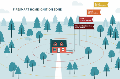 | Figure 20.1: |
4.2. For subdivisions, register the following landscaping provisions either as part of a registered building scheme or a restrictive covenant in order to support ongoing mitigation of risks. For multi-family, commercial, industrial, institutional developments and associated accessory buildings grater than 30 m2 ensure the following are considered as part of landscape design and maintenance. These provisions apply to the area on a property within 10 metres (Priority Zone 1) of the dwelling units as illustrated in Figure 20.1.
- Landscape using the City of Kelowna’s FireSmart® Landscaping Guidelines.
- Ensure there are no trees, limbs or shrubs overhanging roofs or growing under the eaves of buildings.
- Space and maintain trees to achieve a minimum 3 metre canopy spacing.
- Remove ladder fuels by pruning coniferous trees so that there are no branches to a height of 2.5 metres (up to three whorls of live branches may be left on smaller trees); and
- Maintain hedges below a height of 2.0 m (juniper and cedar hedges are prohibited).
- Construct fences with non-combustible fencing materials.
- Keep piled debris (firewood, building materials, and other combustible material) out of Fire Priority Zone 1; and
- Remove (at least annually) surface litter, downed trees and dead and dying trees.