2040 Official Community Plan - Development Permit Area
Farm Protection


Sec. 488 (1) (c) of the Local Government Act allows for the protection of farming.
Unless exempted (See Exemptions section below) a development permit addressing protection of farming guidelines (See Guidelines section below) must be approved for any development located adjacent to the Agricultural Land Reserve (ALR), including properties that abut and are contiguous to agricultural lands as well as properties that would be contiguous if not for a street, lane, walkway, stream, utility lot, underground pipeline, power line, drainage ditch, watercourse, or similar feature, before
- Subdivision of land; or
- A Building Permit.
Agriculture is a prominent land use in Kelowna and a vital component of the local economy. The BC Agricultural Land Commission and the BC Ministry of Agriculture have acknowledged that the development of lands adjoining or reasonably adjacent to farmlands may compromise their agricultural use. As growth continues in the City, the potential for land use conflicts adjacent to agricultural areas increases, necessitating the application of guidelines with respect to subdivision design, buildings, site layout, landscaping and buffering. The guidelines are expected to promote greater compatibility between the uses while protecting the agricultural uses from urban impacts and minimizing complaints for the benefit of both farm and urban residents.
- Minimize the impact of urban development on ALR lands;
- Mitigate conflict between ALR land and adjacent residential, commercial, industrial or institutional uses;
- Develop effective vegetated buffers along the ALR boundary;
- Plan new development in a manner that protects the long-term agricultural potential of adjacent ALR land;
- Provide a natural barrier to block noise, sight, and trespassers;
- Reduce odour, dust, and pesticide drift; and
- Provide greater definition of the boundary of the ALR.
A Farm Protection Development Permit, for properties adjacent to the ALR, will not be required for:
- The subdivision of land already provides the prescribed agricultural buffer (see Guidelines) for all impacted property lines and is protected through a covenant; or
- Development on an existing lot, that does not require subdivision, and is separated from the ALR due to a slope greater than 30%; or
- A lot that is adjacent to an ALR property that is zoned for public and institutional uses (such as parks, schools, utilities); or
- A lot that has existing vegetation that meets the vegetated buffer requirements outlined in these development permit guidelines, as long as the intent of the guidelines for all other requirements have been met; or
- A lot separated by a street identified as an arterial or collector road as per Map 13.1 Functional Classification Map.
- Construction, addition or alteration not exceeding 50 m2 (538 ft2) gross floor area where no variance(s) of the Zoning Bylaw is (are) required; or
- Interior / exterior building alterations that do not expand the existing building foundation; or
- Repair, maintenance, alteration or reconstruction of existing legal buildings, structures or utilities, providing there is no expansion of the footprint; or
- Replacement of a building that has been destroyed by natural causes, in cases where the replacement building is identical to the original in location, floor area and height.
A. Guidelines for New Subdivisions
1.1 Design the subdivision to minimize the impacts that may occur between farm and non-farm uses on adjacent ALR land through the following:
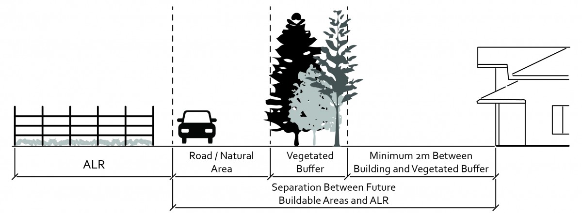
- Strive to achieve a separation between future buildable areas and the ALR as defined in the British Columbia Ministry of Agriculture’s Guide to Edge Planning, 2015, as amended. A modified separation distance may be considered if the following is achieved:
- Residential/Institutional: 15 meter vegetated buffer as described in section 2.0, plus 2 meter no build zone between future structure and buffer (17 meters total)
- Industrial/Commercial: 8 meter vegetated buffer, as described in section 2.0, plus 2 meter no build zone between future structure and buffer (10 meter total)
- Include a vegetated buffer (as described in section 2.0) within the separation between the future buildable area and the ALR;
- Ensure structures are a minimum of 2.0 meters away from the vegetated buffer area to ensure that the buffer is not impacted by building maintenance or pathways required to enter or exit a building;
- Cluster the lots, buildings, or structures away from ALR land as illustrated in Figure 22.1;
- Avoid road endings or stubs which point directly into ALR land as illustrated in Figure 22.2;
- Avoid half roads along the ALR boundary as illustrated in Figure 22.2, except where required for access by farm vehicles;
- Plan the road pattern in such a way to direct urban traffic away from routes used by farmers to move equipment; and
- Avoid utility extensions into ALR land.
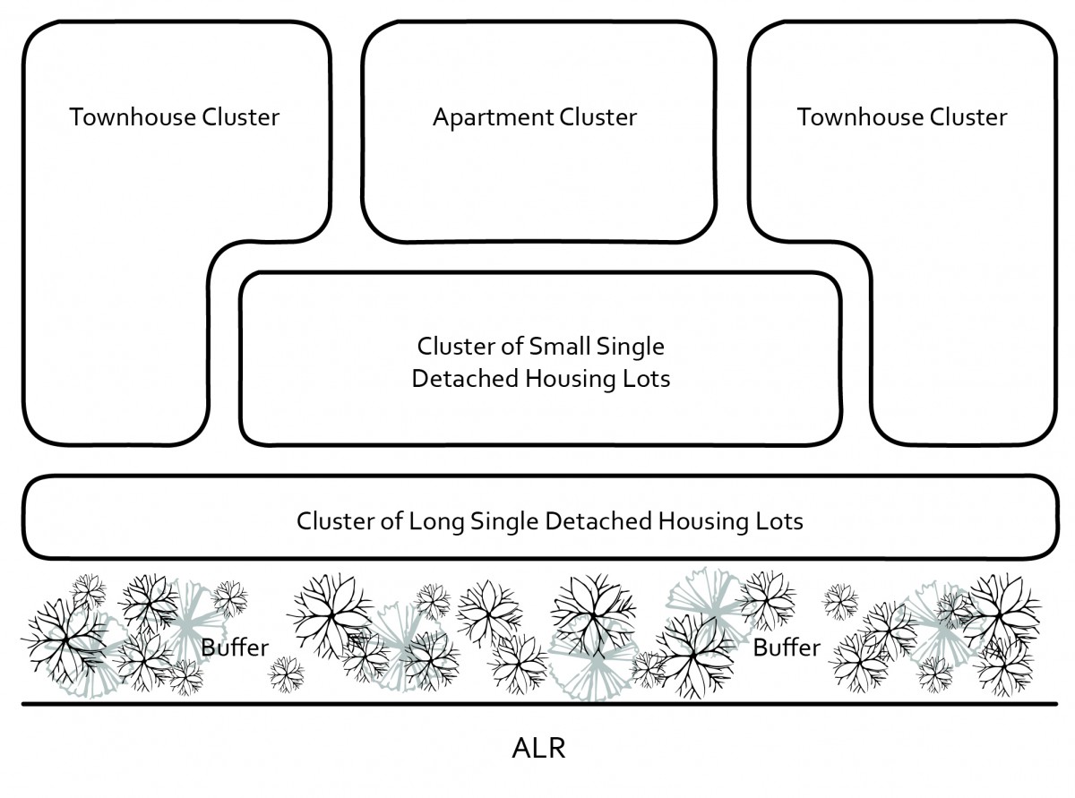 |
| Figure 22.1: Example of residential clustering adjacent to agricultural land. Source: Adapted from BC Ministry of Agriculture Edge Planning Guide. |
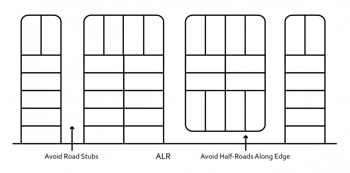 |
| Figure 22.2: Avoid road stubs and half-roads along the boundary of agricultural land. Source: Adapted from BC Ministry of Agriculture Edge Planning Guide. |
2.1 Vegetated buffer width
- Strive to achieve the vegetated buffer widths outlined in British Columbia Ministry of Agriculture’s Guide to Edge Planning, 2015, as amended continuous vegetated buffer is established along the urban side of the ALR.
 |
| Figure 22.3: Example of ground level view of vegetated buffer along the ALR boundary. |
2.2 Vegetated buffer design
- Design, establish and maintain the vegetated buffer to: filter noise, dust, airborne particulates and chemical spray drift from activities on adjacent ALR land.
- Design and construct the vegetated buffer in accordance with Figure 22.3 and Figure 22.4, or equivalent.
- Design and construct the vegetated buffer to the standards outlined in the British Columbia Society of Landscape Architects / British Columbia Nursery Landscape & Nursery Association “The British Columbia Landscape Standard,”2012, as amended.
- Avoid paths and/or passive recreational activities within the vegetated buffer.
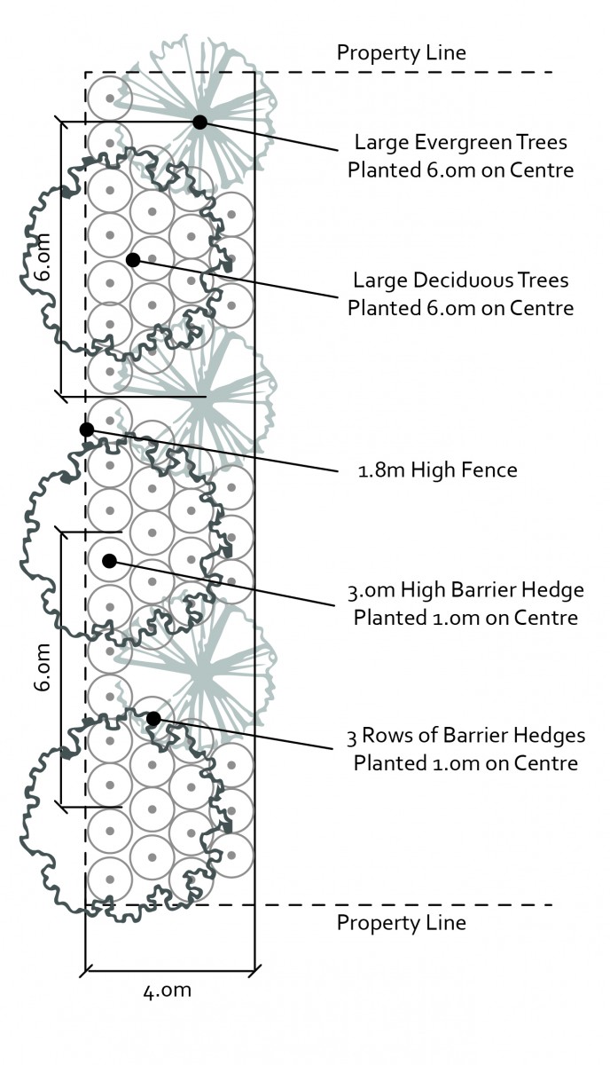 |
| Figure 22.4: Example of vegetated buffer landscape plan for 4 m width, adjust plantings to accommodate a larger vegetated buffer width. |
2.3 Planting the vegetated buffer
- Retain appropriate existing tree and shrub cover in a natural state.
- Select planting material from the British Columbia Ministry of Agriculture’s Guide to Edge Planning, 2015, as amended, for Kelowna’s climate zone. Choose species that are:
- Non-invasive;
- Drought tolerant or require minimal irrigation;
- Low maintenance and require little or no fertilizer;
- Native to the area where possible;
- Not harmful to nearby crops and do not harbor insects or diseases;
- A deterrent to prevent trespass onto farms; and
- Deer resistant.
- Existing vegetation may serve as the entire buffer, provided it meets the objectives of these development permit guidelines.
3.1 Install a fence along the ALR boundary and/or property line. Construct fencing:
- Up to the maximum height permitted by the Zoning Bylaw;
- With solid wood, chain link, or wire mesh fabric (deer fencing).
5.1 A statutory restrictive covenant under section 219 of the Land Title Act, on non-agricultural land may be required during the subdivision process. The covenant shall:
- Require a 2 meter no-build zone between the vegetated buffer and future structure;
- Require vegetated buffers to be maintained to the specified width and planting diversity;
- Require no habitable structures shall be built within setback or buffer area;
- Restrict the planting of species that may potentially host diseases or pests; and
- Specify the lot is located near an agricultural area, that the following impacts from normal farm practices can be expected, such as:
- Noise from farm operations at various times of the day, including devices used to deter wildlife;
- Farm odours;
- Chemical spray (e.g. fertilizers, pesticides, herbicides).
B. Guidelines for Development on an Existing Lot
(Residential, Commercial, Industrial, Institutional, or Public)
1.1 Design the site to strive to achieve the separation between the structure and ALR boundary outlined in British Columbia Ministry of Agriculture’s Guide to Edge Planning, 2015, as amended.
When multiple uses occur on the lot, design the site using the most stringent separation between the structure and the agricultural land boundary.
1.2 Include a vegetated buffer (as described in section 3.0) within the separation between the future buildable area and the ALR boundary.
1.3 Locate structures a minimum of 2.0m from the vegetated buffer area (see section 3.0) to ensure that the buffer is not impacted by building maintenance or pathways required to enter or exit a building.
1.4 Design the development to protect the required vegetated buffer (see section 3.0) from potential negative impacts related to on-site activities (i.e. drainage, recreational pathways, driveways).
1.5 Design buildings to reduce the number of doors and windows facing agricultural land.
1.6 Provide mechanical ventilation so occupants can choose to keep windows closed.
1.7 On institutional sites, locate active uses away from adjacent ALR land to reduce the potential impact from agricultural activities on seniors, children and people with health challenges as illustrated in Figure 22.5. Instead locate passive uses such as parking or gardens near the ALR edge.
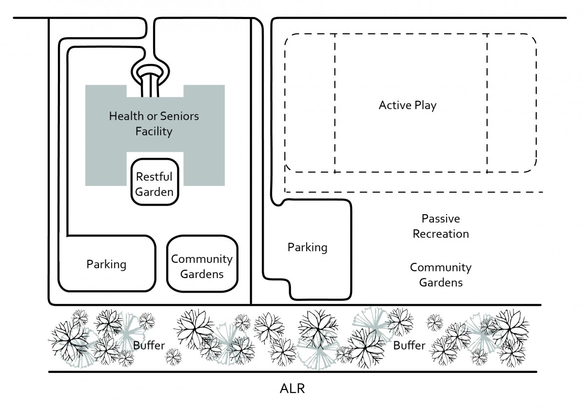 |
| Figure 22.5: Example of institutional and park designs to limit impact on vulnerable populations. Source: Adapted from BC Ministry of Agriculture Edge Planning Guide. |
1.8 On park sites, locate active recreation facilities, such as playing fields, away from the ALR boundary as illustrated in Figure 22.5.
2.1 Consider locating access routes and parking in the yard area between the vegetated buffer and the building to maximize the separation between the use and ALR boundary as illustrated in the example in Figure 22.6.
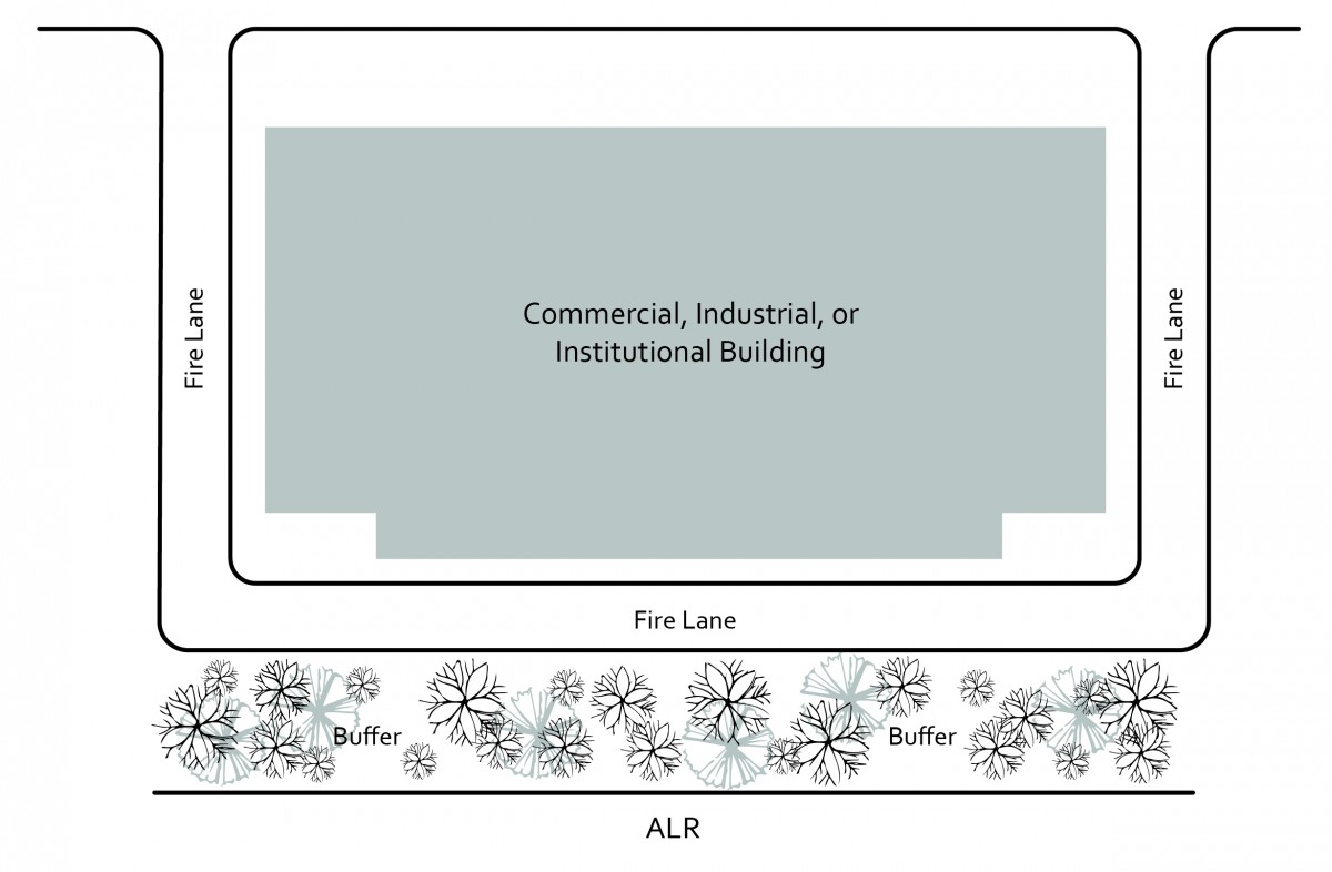 |
| Figure 22.6: Example of fire lane adjacent to vegetated buffer. Source: Adapted from BC Ministry of Agriculture Edge Planning Guide. |
3.1 Vegetated buffer width
- Strive to achieve the vegetated buffer widths outlined in British Columbia Ministry of Agriculture’s Guide to Edge Planning, 2015, as amended, ensuring a continuous vegetated buffer is established along the urban side of the ALR boundary. For smaller, constrained lots, achieve the following minimum vegetated buffer:
- 4.0 meters for residential development on existing lots;
- 6.0 meters for, multi-family, commercial or industrial developments. If there is a street separating the multi-family, commercial or industrial development from the ALR edge, the vegetated buffer may be reduced to 4.0 meters.
When multiple uses occur on the lot, the most stringent buffer width prevails.
3.2 Vegetated buffer design
- Design, establish and maintain the vegetated buffer to: filter noise, dust, airborne particulates and chemical spray drift from adjacent ALR land.
- Design and construct the vegetated buffer in accordance with Figures 22.7 and 22.8, or equivalent.
- Design and construct the vegetated buffer to the standards of the British Columbia Society of Landscape Architects / British Columbia Nursery Landscape & Nursery Association The BC Landscape Standards, 2012, as amended.
- Ensure the vegetated buffer is a ‘no build zone.’ This area should be free of buildings, pools, tennis courts, or other similar structures. Exceptions will be made for accessory structures that do not contain a dwelling unit and have no openings on the wall facing the agricultural lands and will protect the integrity and intent of the remaining vegetated buffer.
- Avoid paths and/or passive recreational within the vegetated buffer.
|
| Figure 22.7: Example of ground level view of vegetated buffer along the ALR boundary. |
3.3 Planting the vegetated buffer
- Retain appropriate existing tree and shrub cover in a natural state.
- Select planting material from British Columbia Ministry of Agriculture’s Guide to Edge Planning, 2015, as amended, for Kelowna’s climate zone. Choose species that are:
- Non-invasive;
- Drought tolerant or require minimal irrigation;
- Low maintenance and require little or no fertilizer;
- Native to the area where possible;
- Not harmful to nearby crops and do not harbor insects or diseases;
- A deterrent to prevent trespass onto farms; and
- Deer resistant
- Existing vegetation may serve as the entire buffer, provided it meets the objectives of these development permit guidelines.
|
| Figure 22.8: Example of vegetated buffer landscape plan for 4 m width, adjust plantings to accommodate a larger vegetated buffer width. |
4.1 Install a fence along the ALR boundary and/or property line. Construct fencing:
- Up to the maximum height permitted by the Zoning Bylaw;
With solid wood, chain link, or wire mesh fabric (deer fencing).
Sec. 488 (1) (c) of the Local Government Act allows for the protection of farming.
As defined in Chapter 17, lands considered agriculture include:
- Lands situated in the Agricultural Land Reserve (ALR); or
- Lands less than 30% slope with a future land use designation of Rural Agricultural and Resource and zoned for agriculture.
Unless exempted (See Exemptions section below) a development permit addressing protection of farming guidelines (See Guidelines section below) must be approved for any development located on Agricultural Lands before:
- Subdivision of land;
- A Building Permit, Soil Permit, or alteration of land unless listed in exemptions below.
To protect the agricultural land resource for present and future production of food and other agricultural products. Guidelines for setbacks and buffering on agricultural lands may assist in minimizing impacts on agricultural neighbours. Impacts may include trespass, crop damage, livestock harassment, and other conflicts.
- Protect farm land and farm operations;
- Minimize the impact of residential uses on farm practice and farming potential in farming areas; and
- Ensure that the primary use of agricultural land is for agricultural purposes.
A Farm Protection Development Permit will not be required for agricultural lands for:
- Agricultural Structures used exclusively for agriculture but excluding alcohol production facilities, farm retail sales, intensive impact agriculture, and facilities for storing, packing, preparing and processing farm products; or
- The issuance of a building permit for single family dwelling housing or accessory structure if a Farm Residential Footprint covenant has been registered with the BC Land Title and Survey Authority and meets the prescribed residential footprint guidelines (see Guidelines); or
- Construction, addition or alteration not exceeding 50 m2 (538 ft2) where no variance(s) of the Zoning Bylaw is (are) required.
1.1 Locate all residential buildings (e.g. houses, garages) and associated structures (e.g. driveways, parking areas, pools, septic fields), including farm help housing, within a contiguous area (i.e. farm residential footprint or homeplate).
1.2 Design the residential footprint such that:
- The residential footprint is located within 60 meters of the road and/or located to maximize agricultural potential and limit negative impacts on the farm, whether or not the parcel is currently farmed;
- For those properties abutting an arterial or collector road, as shown in Map 13.1 Functional Classification Map, the location of the residential footprint considers the impacts of potential future road projects;
- All underground residential services are located within the residential footprint;
- Only structures exclusively used for agriculture, including greenhouses, farm retail sales stands, and those structures associated with crop storage, on-farm processing, stables, alcohol production facilities, and tasting facility or lounge, and temporary farm working housing may be located outside the residential footprint.
1.3 Temporary Farm Worker Housing
- All existing dwellings within the farm unit should be utilized prior to building new temporary farm worker housing, unless the existing dwellings are for a use consistent with the Agriculture Land Commission Act. Alternatively, the existing dwellings on the farm unit must be removed, decommissioned to an approved use or demolished including decommissioning the existing septic system, prior to the authorization of a new temporary farm worker housing structure.
- The temporary farm worker housing footprint should be contiguous with the residential footprint (i.e. homeplate) and / or within 60 metres of the road and/or located to maximize agricultural potential and limit negative impacts on the farm parcel.
- Establish a minimum 3 metre wide vegetated buffer for screening to adjacent property lines and between the temporary farm worker housing and active farming areas.
1.4 Farm help dwelling (permanent)
- Through the development process, a statutory restrictive covenant under section 219 of the Land Title Act is required indicating that the dwelling is for full time farm help and must be removed should the level of operation change such that the operation does not qualify for full time farm help.
- The farm help dwelling (permanent) must be on the same lot as the principal dwelling.
- Design the farm help dwelling (permanent) residential footprint such that:
- It is contiguous with the farm residential footprint (i.e. Homeplate)
- The size is up to 1,000m2 and must be registered on title for farm help dwelling (permanent).
- All underground residential services are located within the farm help dwelling (permanent) residential footprint.
- Establish a minimum 3 metre wide vegetated buffer for screening to adjacent property lines and between the farm help dwelling (permanent) and active farming areas.
1.5 Locate farm retail sales, alcohol production facilities, and any other structures and services related to the public that are defined as farm uses under the ALC Act near the road entrance or in a location that minimizes road construction to reduce the footprint and extent of services through the lot with the goal of reducing impact on the agriculture potential.
2.1 Parking pads should be constructed using permeable materials, such as gravel. Avoid pavement and concrete.
2.2 Parking should be contiguous with the use and located to maximize agricultural potential.