2040 Official Community Plan - Development Permit Area
Natural Environment


Sec. 488 (1)(a) of the Local Government Act allows for the protection of the natural environment, its ecosystems and biological diversity.
Unless exempted (See Exemptions Section below) a development permit addressing natural environment guidelines (see Guidelines Section below) must be approved for those properties shown as Natural Environment Development Permit Areas (DPA) on Map 21.1 before:
- Subdivision of land;
- Alteration of land, including but not limited to clearing, grading, blasting, preparation or construction of services, roads and trails;
- Drilling a well for consumptive or geothermal purposes; and/or
- Construction of, addition to, or alteration of a building or structure.
There are many environmentally sensitive and groundwater resources within the City of Kelowna that have high intrinsic value and are therefore important to the City and its citizens. These areas have been designated as Natural Environment DPAs. The City of Kelowna uses this authority to require development permits for proposals that may impact the environment, ground and surface water, or other natural conditions. The DPA designation for protection of the natural environment is intended to complement federal and/or provincial acts and regulations.
Aquatic ecosystems encompass watercourses of all types including creeks, streams, rivers, ponds, lakes, wetlands, and springs, as well as associated riparian management areas, which are areas of land and vegetation adjacent to watercourses that help maintain healthy aquatic environments. These ecosystems have been identified through inventories commissioned by the City and through partnerships with provincial and federal initiatives. Sensitive aquatic ecosystems are designated as Natural Environment DPA’s because of their environmental significance as habitat for fish and wildlife, there ecosystem connectivity, their vital functions in natural water storage and flood protection, their role in reducing climate change impacts by acting as sinks for carbon dioxide and attenuating water flows, their ability to protect water quality, and their sensitivity to disturbance by development.
Terrestrial sensitive ecosystems encompass areas such as old coniferous forests, coniferous woodlands, grasslands and sparsely vegetated ecosystems including rock outcrops, talus and cliffs. These ecosystems have been identified through inventories commissioned by the City and through partnerships with provincial and federal initiatives. These areas are designated as Natural Environment DPAs due to their environmental significance as habitat and connectivity for wildlife, their contribution to local and regional biodiversity, and their sensitivity to disturbance by development.
The Okanagan Ecosystem Connectivity Corridor (the Corridor), as illustrated in Map 14.1., along the southern and eastern edge of the City is part of a larger regional ecosystem extending from Okanagan Mountain Provincial Park to Kalamalka Lake Provincial Park. It connects sensitive terrestrial ecosystems, watercourses and sensitive drainage areas as one natural functioning low elevation ecosystem which is appropriate for our dry interior species. The Corridor is sensitive to development disturbance and is designated as a Natural Environment DPA due to its significance as unique natural ecosystems, the importance of protecting connectivity for biodiversity, climate regulation, species movement, resiliency to environmental disturbance such as climate change, and ecosystem services that contribute to human well-being.
As part of the City’s Sensitive Ecosystem Inventory, sensitive drainage areas were identified based on soil drainage, slope position, slope morphology and geomorphic processes. These areas have evolved over thousands of years creating a sensitive equilibrium with water discharge, and as such have been identified as Natural Environment DPA.
The City of Kelowna also protects sensitive groundwater resources through the Natural Environment Development Permit Process. With the exception of the City of Kelowna, the other major water suppliers in the City rely partially on groundwater to provide drinking water to citizens in their respective service areas. As groundwater is used for domestic use and consumption, protecting Kelowna’s aquifers should be given priority through quality and quantity protection measures. Groundwater can also sustain important habitat as base flow or discharge to surface water sources. As a result, care must be taken to ensure that existing land uses, and future developments do not contaminate underlying aquifers and promote their sustainable use. Mitigation is promoted and enhanced through the issuance of Natural Environment Development Permits for relevant properties.
Overall, the Natural Environment Development Permit process is used to determine how adverse environmental impacts can or cannot be decreased using appropriate precautionary measures as part of site and building design, construction, and long-term maintenance.
The objectives of Natural Environment DPAs are to ensure that negative impacts on environmental sensitive areas are minimized by:
- Protecting, restoring and enhancing environmentally sensitive areas as functioning ecosystems;
- Protecting and enhancing water quality;
- Protecting drinking water sources and subsurface aquifers against possible contamination from land use and development activities;
- Managing the introduction and spread of invasive species;
- Minimizing soil disturbance;
- Protecting hydrological functions;
- Protecting biodiversity, as well as wildlife habitats, features and functions; and
- Promoting the efficient use of water to ensure a sustainable hydrologic system.
A Natural Environment Development Permit will not be required when:
- A property has a covenant registered under the Land Title Act, which effectively protects the entire environmentally sensitive area, and all the conditions in the covenant have been met, and the proposed development will not affect any portion of the environmentally sensitive area; or
- The land is not environmentally sensitive and the natural feature is no longer present due to previously approved development, and cannot be restored. For the City to determine whether the proposed development qualifies for this exemption, applicants may be required to provide a report on the condition of the environmentally sensitive area, prepared by a Qualified Professional (QP), registered in British Columbia; or
- The proposed development will have no significant negative impacts on the environmentally sensitive areas identified on the property and/or the environmentally sensitive area is permanently protected. For the City to determine whether the proposed development qualifies for this exemption, applicants may be required to provide a report on the development and the environmentally sensitive area, prepared by a Qualified Professional (QP) registered in British Columbia ; or
- The only activity being proposed onsite relates to the removal of hazardous and beetle kill tree(s). For the City to determine whether the proposed activity qualifies for this exemption, applicants may be required to provide a report prepared by a certified forestry professional, registered in British Columbia holding either a) Wildlife/Danger Tree Assessor qualifications or b) Tree Assessment Qualifications (TRAQ) ; or
- The development activity is on Crown Land and involves timber harvesting, forest road construction, open livestock range, grazing enhancement, forest recreation or other forest management activity that is conducted under the auspices of the province; or
- The actions and activities are necessary to prevent immediate threats to life or property; or
- The activity proposed on the site will not impact the environmentally sensitive area and the activity relates solely to normal farm practices in accordance with the Farm Practices Protection Act and the landowner follows other requirements or regulations listed in the Act; or
- The activity proposed is on a property that is less than 0.2 ha and is subject to a Natural Environment DP for an ecosystem connectivity corridor only and no other reason, provided the activity allows for movement of wildlife.
The general guidelines for issuing development permits in Natural Environment Development Permit Areas are listed below; however, not all guidelines will apply to all developments. Typically an assessment report which has been prepared by a professional qualified in the relevant discipline and licensed to practice in British Columbia will be required. Report recommendations may be used by the Development Planning Department Manager, or designate, to determine conditions for the Development Permit.
Many properties will be affected by more than one environmentally sensitive attribute, and as such all applicable development permit guidelines should be followed. For example a property may be designated a Natural Environment DPA because of a terrestrial sensitive ecosystem and it may also have sensitive drainage areas so both sections 2.0 and 3.0 would apply.
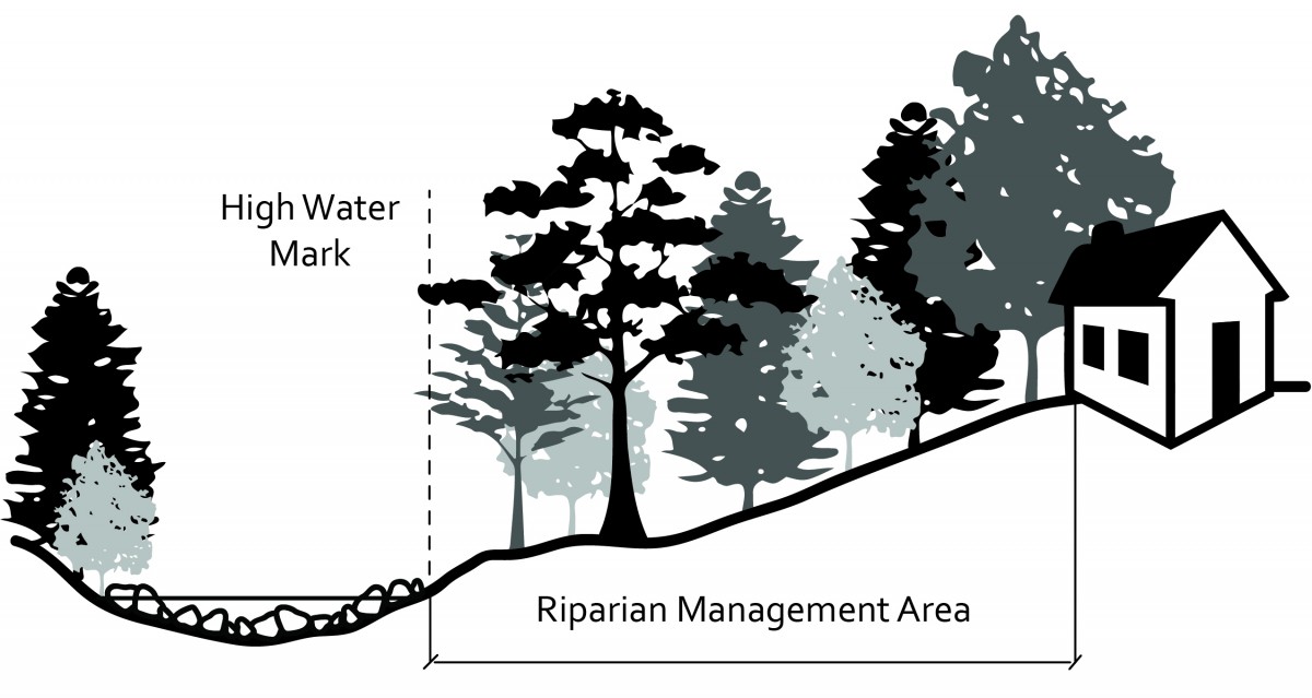 |
| Figure 21.1: The Riparian Management Area. Source: Adapted from Ministry of Forests, Lands, and Natural Resource Operations. |
| Watercourse1 | Watercouse Reach | RMA (meters)2,3 | |
|---|---|---|---|
| 1 | Bauer Brook | All | 15 |
| 2 | Bellevue Creek | All | 15 |
| 3 | Bellevue Creek (North Arm) | downstream of 4544 Gordon Drive | 10 |
| 4 | Bertram Creek | All | 15 |
| 5 | Brandt Creek | All | 15 |
| 6 | Bruce Creek | All | 15 |
| 7 | Campbell Brook | All | 15 |
| 8 | Cedar Creek | All | 15 |
| 9 | Dewdney Creek | All | 15 |
| 10 | Duggan Brook | All | 15 |
| 11 | Fascieux Creek (North and South Arm) | All | 15 |
| 12 | Francis Brook | All | 15 |
| 13 | Gopher Creek | All | 15 |
| 14 | Hachey Creek | All | 15 |
| 15 | Hydraulic Creek | All | 15 |
| 16 | Industry Brook | All | 15 |
| 17 | K.L.O. Creek | All | 15 |
| 18 | Okanagan Lake | All | 15 |
| 19 | Lebanon Creek | All | 15 |
| 20 | Leon Creek (aka Thompson Creek) | All | 15 |
| 21 | Michael Brook | All | 15 |
| 22 | Mill Creek | Downstream of Hardy Street | 15 |
| 23 | Mill Creek | Upstream of Hardy Street | 30 |
| 24 | Mission Creek | Downstream of Gordon Drive | 15 |
| 25 | Mission Creek | Upstream of Gordon Drive | 50 |
| 26 | Priest Creek | All | 15 |
| 27 | Rembler Creek | All | 15 |
| 28 | Rumohr Creek | All | 15 |
| 29 | Scotty Creek | All | 15 |
| 30 | Simpson Spring | All | 15 |
| 31 | Thompson Brook | All | 15 |
| 32 | Varty Creek | All | 15 |
| 33 | Upper Vernon Creek | All | 15 |
| 34 | Whelan Creek | All | 15 |
| 35 | Wilson Creek | All | 15 |
| 36 | Wetlands (no association with fish habitat) | All | 15 |
| 37 | Wetlands (associated with fish habitat) | All | 30 |
| 38 | Escarpments or ravines | All | 10 |
| 39 | Springs | All | 15 |
Notes for Table 21.1
- Any watercourse not in this list is subject to the provincial acts and regulations.
- Measured perpendicularly inland from the top of the bank, top of ravine or natural boundary, as applicable. RMA’s apply to both sides of the stream.
- Minimum RMA widths are intended to achieve “no net loss” when considering individual site conditions.
1.1 Meet or exceed the requirements of the provincial Riparian Areas Protection Regulation under the Riparian Areas Protection Act. At minimum, projects must comply with Riparian Management Area Setbacks in Table 21.1, unless conditions of Section 1.3 apply.
1.2 Measure the riparian management area setback width perpendicular from the watercourse according to the following (see Table 21.1):
- Streams – measured from the top-of-bank, or where the top-of-bank is poorly defined, measured from the natural boundary;
- Ravines and other stream corridors with steeply pitched banks – measured from the top of ravine bank;
- Wetlands and lakes with gradually sloping shores – measured perpendicularly from the natural boundary; and
- Okanagan Lake – measured from the high water mark of 343.0 m, as determined by the Province based on the highest target lake level plus 0.5m to account for wave action. The high-water mark for some sites may be higher or lower where natural indicators on the shoreline show that wave action or other hydrological processes affect the shoreline to such an extent that the recommended high water mark is not applicable at that site. In these instances a site-specific high-water mark can be used where a QP has provided a signed technical rational for why the high water mark is not applicable, and this is accepted by both the City and the Province. The minimum acceptable high-water mark is the highest target lake level (342.48 m) plus 0.1 m.
1.3 Riparian Management Area Variances
- Applicants may apply to vary the width of the Riparian Management Areas listed in Table 21.1 should they be able to demonstrate hardship on the property and/or if the land was previously disturbed.
- Support of RMA variance applications will only be considered by the City to achieve “no net loss” and where an assessment, completed by a QP, provides recommendations to protect the integrity of the riparian area.
- Refer proposed relaxation of riparian management areas, storm water requirements, erosion and sediment control requirements to the City for review prior to filing the QP assessment report with the appropriate provincial ministry or agency.
- Restore the riparian management area as directed by the report of the QP when required by the Development Permit.
1.4 Biodiversity and Habitat Protection
- Ensure riparian areas act as ecological connectivity corridors to allow for the movement of species by retaining intact ecosystems and their connectivity and reconnecting fragmented ecosystems.
- Maintain intact ecosystems. An intact ecosystem is considered to be a community or ecosystem that is maintaining proper function and has not lost significant species (for communities) or significant communities (for ecosystems).
- Improve the viability of threatened and endangered species through the protection, enhancement, and restoration of habitat, as well as the development of contingency plans for major disruptions and transplanting wild or captive bred individuals.
- Undertake recovery efforts to enhance or re-introduce species, subspecies and populations where species are threatened, endangered or extirpated.
- Retain connectivity of ecosystems and avoid the creation of isolated islands of natural habitat.
- Locate artificial snags to improve habitat.
- Encourage the “eco-gifting” of privately held riparian management areas through a conservation easement, covenant, or other mechanism as a means of protecting biodiversity.
1.5 Buffers and Vegetation
- Establish buffers as outlined in Table 21.1, to protect the ecological integrity of the riparian management area.
- Protect buffers on private land with a Section 219 covenant, when required.
- Install fencing along the buffer, where appropriate.
- Maintain ecosystems in an undisturbed state during and after the development process (e.g. avoid disturbance to sites where rare plants are growing and where rare natural plant communities occur).
- Conserve trees and protect their root systems from disturbance.
- Conserve trees in communities (groups of trees along with their associated understory) rather than isolating individual specimen.
- Restore ecosystems by planting species that are:
- Indigenous to the Okanagan Valley;
- Pest-resistant;
- Adapted to the specific site conditions today (soil type, sun, shade, and moisture) and for a changing climate.
- Remove invasive species (manually where feasible) and take measures to prevent their spread.
- Protect moderate and high value wildlife trees, as assessed by a QP, from removal where the hazard risk to humans is low.
- Retain snags, leaf litter, fallen debris and natural grasslands in a manner that balances FireSmart® principles with ecosystem retention.
1.6 Urban Development (roads, housing, services and utilities)
- Require development take place outside the riparian management area.
- Avoid locating infrastructure corridors along, parallel to, or across riparian ecosystems. Where it can be demonstrated by a QP that alternatives are not possible, design crossings that are narrow and perpendicular to sensitive areas and elevated to maintain ecosystem connections.
- Design infrastructure to maintain the hydrology of aquatic ecosystems.
- Design infrastructure corridors and trails to be as narrow as possible, creating minimum disturbance and configure them to accommodate wildlife crossings.
- Construct accesses such as footpaths and stairways to minimize slope disturbance and changes to natural drainage patterns.
- Consider removing existing structures and other obstructions from the riparian management area to allow for movement of wildlife.
- Site all service lines outside of the riparian management area to:
- Minimize slope disturbance;
- Discourage invasive weed growth; and
- Require minimal maintenance by heavy equipment.
- Restore disturbed areas quickly (with consideration given to hydrologic and climatic variables) to minimize erosion, ensure sediment control and prevent the spread of invasive weeds.
1.7 Fill
- Require the toe of any fill be located outside the riparian management area.
- Require the face of the fill be no steeper than a 3:1 slope unless retained by an approved structure.
- Require the fill be adequately protected against erosion from potential flooding, wave action, ice or other debris.
1.8 Soil Disturbance
- Where appropriate, require that sediment and erosion control plans be developed and/or reviewed by a QP.
- Implement measures to minimize soil disturbance and removal of gravel, sand, soils and peat.
1.9 Erosion Control
- Take temporary and permanent measures to control contamination from sediment and pollutants and to control erosion as outlined in the Subdivision, Development and Servicing Bylaw.
1.10 Minimize the negative impacts of livestock (e.g. grazing, water access, crossings) in riparian areas.
1.11 Water and Drainage
- Ensure development activities do not negatively impact the quality of surface water.
- Ensure land development and associated activities do not impact base flows, natural drainage patterns or natural stream channel geometry.
- Preserve natural watercourses and manage them as open streams.
- Maintain normal riparian processes such as flooding, seasonal drawdown, and groundwater recharge.
1.12 Lakeshore stabilization
- Complete an assessment and design of lakeshore stabilization works by a QP.
- Do not reclaim eroded land below the lake high water mark.
- Use vegetative stabilization (bioengineering) techniques to prevent erosion, control sediment and provide fish and wildlife habitat in low to moderate wave action areas. For moderate to high wave action areas use a combination of vegetation and natural hard structures such as large woody debris and/or rip rap. Where engineer designed hard armoring is required due to high wave action, a technical rationale and design proposal must be provided to the City by a QP. Avoid using broken concrete, tires and other anthropogenic materials for stabilization.
- Ensure lakeshore stabilization works maintain existing wildlife access to the lake foreshore.
2.1 Biodiversity and Habitat protection
- Retain intact ecosystems and their connectivity. Where practical and necessary, reconnect fragmented ecosystems by restoring habitat. Avoid the creation of isolated islands of natural habitat.
- Ensure ecosystem connectivity corridors are large enough to sustain species populations and prevent isolated habitat patches. Determine the location and extent of corridors using contemporary best management practices.
- Improve the viability of threatened and endangered species through the protection, enhancement, and rehabilitation of habitat, as well as the development of contingency plans for major disruptions and transplanting wild or captive bred individuals.
- Undertake recovery efforts to enhance or re-introduce species, subspecies and populations where species are threatened, endangered or extirpated.
- Plan, design and implement development to protect environmentally sensitive areas. Habitats that provide for species at risk, at-risk ecological communities and keystone species will be given priority for protection over development.
- Maintain intact ecosystems. An intact ecosystem is considered to be a community or ecosystem that is maintaining proper function and has not lost significant species (for communities) or significant communities (for ecosystems).
- Protect nesting, denning and breeding sites.
- Protect rock outcrops, cliffs, and talus slopes from disturbance.
- Locate artificial snags to improve habitat.
- Encourage the “eco-gifting” of privately held terrestrial sensitive ecosystems through a conservation easement, covenant, or other mechanism as a means of protecting biodiversity.
2.2 Buffers and Vegetation
- Establish buffers that are large enough to protect the ecological integrity of the environmentally sensitive area. The exact location and extent of buffer areas will be determined by best management practices.
- Protect buffers on private land with a Section 219 covenant, when required.
- Install fencing along the buffer, where appropriate.
- Maintain ecosystems in an undisturbed state during and after the development process (e.g. avoid disturbance to sites where rare plants are growing and where rare natural plant communities occur).
- Retain trees and vegetation in a manner that balances BC Fire Smart principles with ecosystem sensitivity.
- Conserve trees and protect their root systems from disturbance.
- Conserve trees in communities (groups of trees along with their associated understory) rather than isolating individual specimen.
- Restore grasslands and shrub communities.
- Restore ecosystems by planting species that are
- Indigenous to the Okanagan Valley;
- Drought-tolerant;
- Pest-resistant;
- BC Fire Smart;
- Compatible with urban development;
- Adapted to the specific site conditions today (soil type, sun, shade, moisture) and for a changing climate.
- Remove invasive species (manually where feasible) and take measures to prevent their spread,
- Protect moderate and high value wildlife trees, as assessed by a QP, from removal where the hazard risk to humans is low.
- Retain snags, leaf litter, fallen debris and natural grasslands in a manner that balances BC Fire Smart principles with ecosystem retention.
2.3 Urban Development (roads, housing, services and utilities)
- Site all service lines outside of environmentally sensitive areas and to:
- Minimize slope disturbance;
- Discourage invasive species growth; and
- Require minimal maintenance by heavy equipment.
- Restore disturbed areas quickly (with consideration given to hydrologic and climatic variables) to minimize erosion, ensure sediment control and prevent the spread of invasive species.
- Avoid the location of infrastructure corridors along, parallel to, or across sensitive ecosystems. Where it can be demonstrated by a QP that alternatives are not possible, design crossings that are narrow and perpendicular to sensitive areas and elevated to maintain connections.
- Construct accesses such as footpaths and stairways to minimize slope disturbance and changes to natural drainage patterns.
2.4 Soil Disturbance
- Where appropriate, require that sediment and erosion control plans be developed and/or reviewed by a QP.
- Implement measures to minimize soil disturbance and removal of gravel, sand, soils and peat.
2.5 Erosion Control
- Take temporary and permanent measures to control contamination from sediment and pollutants and to control erosion as outlined in the Subdivision, Development and Servicing Bylaw.
2.6 Fill
- Require the face of the fill be no steeper than a 3:1 slope unless retained by an approved structure.
- Require the fill be adequately protected against erosion from potential flooding, wave action, ice or other debris.
3.1 Ensure that development activities do not negatively impact the quality of surface water.
3.2 Ensure that land development and associated activities does not impact base flows, natural drainage patterns and the natural stream channel geometry.
3.3 Preserve natural watercourses and manage as open streams.
3.4 Maintain normal riparian processes such as flooding, seasonal drawdown, and groundwater recharge.
3.5 Implement measures to prevent spills of oil, grease and other contaminants into adjacent watercourses (e.g. oil/grit separators and siltation ponds).
3.6 Minimize impervious surfaces through use of permeable materials and techniques to improve absorption (e.g. gravel, pavers, grasscrete, grass field for overflow parking, “country lanes”).
3.7 Prohibit unnatural obstructions and impediments to the flow of a watercourse, ditch, drain or sewer.
3.8 Manage and minimize opportunities for livestock crossings and access to water.
3.9 Require drainage plans address the effective and environmentally sensitive handling of peak flows.
3.10 Buffers and Vegetation
- Retain as much existing vegetation as possible and plant native trees and shrubs to restore the vegetative where clearing has occurred. Plant species that are:
- Indigenous to the Okanagan Valley;
- Drought-tolerant;
- Pest-resistant;
- FireSmart®;
- Compatible with urban development;
- Adapted to the specific site conditions today (soil type, sun, shade, moisture and for a changing climate.
- Protect buffers on private land with a Section 219 covenant, when required.
- Retain trees and vegetation in a manner that balances FireSmart® principles with ecosystem sensitivity.
- Conserve trees and protect their root systems from disturbance.
- Conserve trees in communities (groups of trees along with their associated understory) rather than isolating individual specimen.
- Remove invasive species (manually where feasible) and take measures to prevent their spread .
- Protect moderate and high value wildlife trees, as assessed by a QP,from removal where the hazard risk to humans is low.
- Retain snags, leaf litter, fallen debris and natural grasslands in a manner that balances FireSmart® principles with ecosystem retention.
3.11 Soil Disturbance
- Where appropriate, require that sediment and erosion control plans be developed and/or reviewed by a QP.
- Implement measures to minimize soil disturbance and removal of gravel, sand, soils and peat.
3.12 Erosion Control
- Take temporary and permanent measures to control contamination from sediment and pollutants and to control erosion as outlined in the Subdivision, Development and Servicing Bylaw.
3.13 Fill
- Require the face of the fill be no steeper than a 3:1 slope unless retained by an approved structure.
- Require the fill be adequately protected against erosion from potential flooding, wave action, ice or other debris.
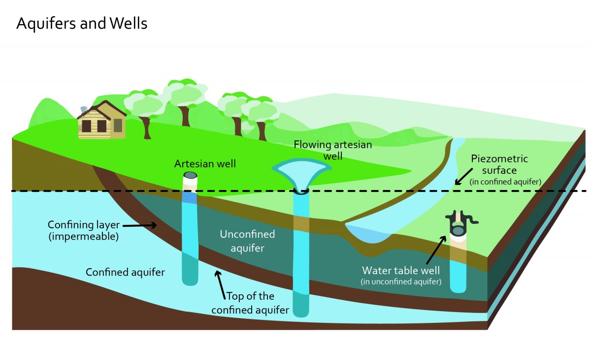 |
| Figure 21.2. Confined and unconfined aquifers and wells. Source: Environment Canada. |
4.1 Prohibit land disturbance that would have a negative impact on groundwater recharge and wellhead protection areas.
4.2 Avoid the use of chemical fertilizers, pesticides and herbicides to protect highly vulnerable aquifers.
4.3 Disconnect and close private wells when a property connects to the City Water Utility as per Bylaw 11770: Well Regulation Bylaw. Encourage the disconnection and closure of private wells for those properties connecting to other local water providers.
4.4 Underground storage tanks
- Require a hydrogeological report, from a QP, assessing the appropriateness of the proposed property and location for underground fuel storage tanks, chemical storage, and/or use/storage of other potential sources of groundwater contamination.
- If the subject property is considered appropriate, provide, and follow recommendations of the QP with respect to the installation and maintenance of tanks/storage containers and other associated infrastructure.
4.5 Minimize the frequency with which the landscape and aquifers are disturbed (e.g. boreholes) to access groundwater flow. As an example, district energy systems are preferred over a series of individual wells for geothermal purposes.
4.6 Earth Energy Systems (Geothermal)
- Conduct a hydrogeological assessment, by a qualified hydrogeological professional prior to the installation of earth energy systems, if required. The assessment must conclude that the system will result in no significant impacts to existing ground and surface water conditions (e.g. temperature and quality).
- Design and install earth energy systems (geothermal) to conform to best management practices.
- Require designers, installers and drillers of earth energy systems to be accredited by Canadian Geoexchange Coalition (CGC).
- Certify earth energy system installations by the Canadian Geoexchange Coalition.
5.1 Biodiversity and Habitat Protection
- Retain connectivity to ecosystems and avoid the creation of isolated islands of natural habitat.
- Where practical and necessary, reconnect fragmented ecosystems by restoring habitat.
- Retain the width of un-fragmented natural habitat for the Okanagan Ecosystem Connectivity Corridor (the Corridor) as 1,000 meters wide, to allow for long-term ecosystem retention and wildlife movement. In rare exceptions, the width may be reduced to a minimum of 50 meters for short distances (e.g. less than 100 meters over the entire Corridor).
5.2 Buffers and Vegetation
- Maintain native vegetation in the Corridor in an undisturbed state during and after the development process (e.g. avoid disturbance to sites where rare plants are growing and where rare natural plant communities occur). Ensure to balance FireSmart principles with natural ecosystem retention.
- Use indigenous vegetation to buffer the Corridor from the built environment wherever possible.
- Where necessary, restore sections of the Corridor by planting species that are:
- Indigenous to the Okanagan Valley;
- Drought-tolerant;
- Pest-resistant;
- FireSmart®; and/or
- Adapted to the specific site conditions today (soil type, sun, shade, moisture) and for a changing climate.
- Remove invasive species (manually where feasible) and take measures to prevent their spread .
- Protect moderate and high value wildlife trees, as assessed by a QP, from removal where the safety risk to humans is low.
- Retain snags, leaf litter, fallen debris and natural grasslands in a manner that balances FireSmart® principles with ecosystem retention.
- Maintain enough vegetative hiding cover as prescribed by a QP when managing areas within the Corridor for fire, disease or weed control.
5.3 Urban Development
- Work with a QP to ensure species movement is maintained through the Corridor and that habitat fragmentation does not occur.
- Design new subdivision within or bordering the Corridor to allow for movement of wildlife and to avoid wildlife entrapment. Consider parcel orientation, minimizing fragmentation, positioning of future structures and other sensitive ecosystems on the property in the design.
- Minimize development (i.e. buildings, structures, etc) within the Corridor to ensure long-term retention of natural ecosystems and unimpeded movement of wildlife.
- In instances where structures are unavoidable, choose locations that minimize habitat fragmentation, such as along the perimeter, while also considering and avoiding other sensitive areas on the property.
- Design the site and structures to minimize impacts on the Corridor. Design considerations should include:
- Placement of structures and infrastructure to minimize corridor fragmentation; including reduced road lengths;
- Minimize the impacts of lighting; and
- Landscaping and fencing (see sections 5.2 and 5.4).
- Avoid locating infrastructure corridors (e.g. roads and utilities) through the Corridor. Where necessary ensure infrastructure corridors are narrow, perpendicular to the Corridor where feasible, minimize disturbance and accommodate wildlife crossings.
- Design trails to be as narrow as possible, creating minimum disturbance to the Corridor.
- Include wildlife crossing structures (e.g. snake or amphibian crossing culverts, or box culverts to connect wetlands and necessary drift fencing) and associated warning signage when a road bisects the Corridor when there is potential to impede wildlife movement.
- Restore disturbed areas quickly, with consideration given to hydrologic and climatic variables, to minimize erosion, ensure sediment control and the spread of invasive weeds.
- Encourage the “eco-gifting” of privately held land in the Corridor, through a conservation easement, covenant, or other mechanism as a means of protecting biodiversity.
5.4 Fencing
- Ensure fencing does not pose any hazards to wildlife or movement within the Corridor. Where wildlife-proof fencing (e.g. for ungulates or snakes) may be required, work with a QP to ensure critical wildlife travel routes are not completely blocked.
- Consider updating or eliminating existing fences that may be hazardous to wildlife (e.g. broken wires and rails).
- On agricultural land, follow fencing recommendations of the British Columbia Ministry of Agriculture’s Agricultural Fencing Handbook Complete Guide, 2015, or as amended,. In instances where tall fences are required around orchards, provide alternate wildlife movement paths where possible and include wildlife escape gates in the fence design.
5.5 Soil disturbance
- Where appropriate, require sediment and erosion control plans developed and/or reviewed by a QP.
- Implement measures to minimize soil disturbance.
5.6 Erosion Control
- Meet erosion and sediment control requirements as outlined in the Subdivision, Development and Servicing Bylaw .
6.1 Mitigation
- In exceptional circumstances where it is determined by a QP that the disturbance cannot be mitigated onsite, ensure offsite environmental improvements occur with the intention of achieving no net loss of critical habitat.
6.2 Ongoing Maintenance
- Require ongoing maintenance of areas that have been rehabilitated or restored as directed by report prepared by a QP.
- Register a Section 219 no build or no disturb covenant for areas that have been rehabilitated or restored.
6.3 Monitoring
- Provide ongoing monitoring of Development Permit conditions by a QP.
6.4 Performance bonding
- Submit to the City, when required, a cost estimate, prepared by a QP and accepted by the City, of the total cost of rehabilitating and/or restoring the environmentally sensitive area.
- Provide adequate financial security, as determined by the City, prior to the issuance of approvals of any building or site disturbance. The value of the financial security will be based upon the estimated cost of:
- rehabilitating and/or restoring an environmentally sensitive area;
- rehabilitating and/or restoring an environmentally sensitive area, in the event that an environmentally sensitive area is damaged as a consequence of a contravention of a condition contained in the development permit;
- restoring fish habitat; and
- repairing damage caused by construction or site disturbance.